Drone media, static marketplace photos, residential 3D-tour apps, flat mapping tools — every land seller has cobbled together some version of these. Here’s how they stack up, feature by feature, against a platform designed from day one to sell dirt.
13 features compared · 5 approaches · ~9 min read
If you sell land, you already know the core problem: a flat photo can’t show slope, road frontage, or what a parcel actually feels like to stand on. Buyers hesitate, ask the same questions on repeat, and stall on price. So most sellers reach for whatever visualization tool is closest to hand — a drone, a marketplace listing template, a 3D-tour app borrowed from the residential world, or a 2D mapping tool.
Each of those does one slice of the job. ParcelView3D was built to do the whole job in a single workflow, specifically for raw and rural land rather than houses. Below, we put all five approaches side by side across the features that actually move a parcel: photorealistic 3D, terrain, overlays, video, AI concept renderings, build-cost estimates, shareable pages, lead capture, and speed to publish.
01 / The Field
The four things land sellers use today
Before the matrix, here’s a fair description of what each alternative is genuinely good at — because a comparison only means something if the other side gets a real shot.
Drone photo & video — Beautiful aerial stills and cinematic clips. The problem is cost, scheduling, weather, and a truck-and-camera trip for every listing.
Static marketplace listings — The default photo-grid listing on the big land marketplaces. Familiar to buyers, but flat, generic, and easy to scroll past.
Residential 3D-tour apps — Great for walking a buyer through a finished house. Built around interior rooms — not slope, acreage, or road access on open land.
2D land-mapping tools — Solid for drawing boundaries and layering data on a flat map. But a top-down 2D map still can’t show a buyer the lay of the land.
02 / The Matrix
Feature by feature
A check means the capability is native and buyer-ready out of the box. An amber label means it’s possible but limited, manual, or bolted on. A dash means it isn’t really there. ParcelView3D is the highlighted column.
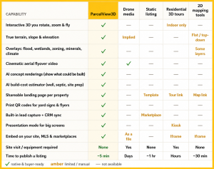
The pattern is hard to miss. Every alternative is strong in its lane and empty everywhere else. ParcelView3D’s advantage isn’t that it beats a drone at cinematic footage or a mapping tool at drawing a boundary — it’s that a buyer gets all of it on one page, and the seller ships it in about the time it takes to make coffee.
| Why it matters
Buyers spend minutes on an interactive 3D listing instead of seconds on flat photos — and the longer they explore slope, frontage, and flood lines themselves, the fewer “is this in the floodplain?” emails you answer and the more serious the calls you get. |
03 / The Difference
Where ParcelView3D pulls ahead
Photorealistic 3D with real terrain
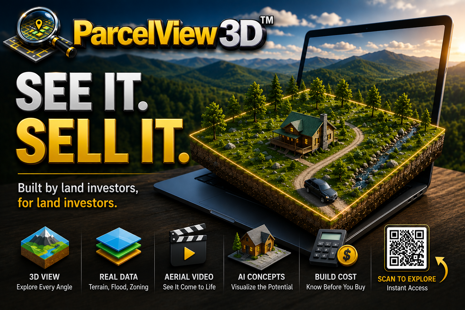
This is the headline. A drone gives you a gorgeous still from one angle on one day; a marketplace listing gives you a thumbnail. ParcelView3D gives the buyer a photorealistic, true-to-terrain 3D model of the actual parcel they can rotate, zoom, and fly around from any angle — reading elevation, slope, and road access the way they would on a site visit. No truck, no camera, no scheduling. Just the parcel ID.
AI concept renderings — sell the potential, not just the dirt
Raw land is hard to sell because buyers can’t picture what goes on it. ParcelView3D generates photorealistic concept renderings — a cabin, a ranch home, an ADU, a barndominium — placed on the real property, so a bare lot suddenly reads as a future homestead. No competing tool in this comparison does this at all.
The build-cost question, answered on the listing
Every land buyer asks the same thing before they wire money: what will it cost to actually build here? Instead of sending them off to cold-call contractors, ParcelView3D’s AI cost estimator shows build cost, site prep, well feasibility, septic suitability, and a total-investment number right on the property card. That single feature removes the biggest source of buyer hesitation — and none of the alternatives touch it.
PropCards™ — every parcel gets its own shareable page
Each property becomes a clean, mobile-first landing page: 3D viewer, photos, concept images, video, pricing, and a built-in lead form, all behind one link. Drop a print-ready QR code on a yard sign or flyer and a passerby is touring the parcel in 3D from their phone in seconds — with their contact info flowing straight into your CRM.
Presentation Mode — close in the room
When you’re across the table from a buyer or a homeowner, Presentation Mode turns any big screen or projector into a full property walkthrough: widescreen layout, fullscreen gallery, inline video, and a QR code for instant mobile follow-up. No slide deck to build. A drone reel can’t respond to “show me the north corner” — this can.
04 / The Money
What each approach really costs
Cost isn’t just the sticker price — it’s the per-listing time and the site visits. Here’s the honest picture for a seller running a portfolio of listings.
| Approach | Per-listing reality | Typical cost |
| Hire a drone videographer | Site visit + 1–2 week turnaround, every property | $400–$800 |
| DIY drone | Your Saturday, plus gear and editing | Time + equipment |
| Static marketplace listing | Flat photos, buyers scroll past | Listing fees |
| Residential 3D-tour app | Built for interiors, not land | $$ / mo + visit |
| ParcelView3D | Paste an APN → live 3D listing in ~5 min, no visit | from $9/mo |
One monthly subscription covers your whole portfolio — 3D viewers, flyovers, concept images, cost estimates, PropCards, QR codes, analytics, and lead capture — for less than the cost of a single drone shoot. And when you want polished ad creative without lifting a finger, the same engine powers a Done-For-You video package.
05 / The Verdict
Which one is right for you?
Here’s the fair read. If all you ever need is one hero video for one flagship property, a great drone operator is hard to beat. If you only list occasionally and don’t mind blending in, a static marketplace listing works. Residential 3D-tour apps are the right call when you’re actually selling finished houses. And a 2D mapping tool is a fine notebook for boundaries and layers.
But if you sell land at any real volume — rural, raw, or developed — and you want buyers to understand a parcel, believe in its potential, and raise their hand as qualified leads, you want the tool that does all of it in one workflow. That’s the whole reason ParcelView3D exists: built by land investors, for land investors, to turn every listing into an experience buyers explore instead of a photo they scroll past.
| TRY IT ON YOUR NEXT LISTING
See a parcel in 3D in about five minutes. 7 days free. List up to 3 properties. No card required. If it doesn’t move them faster, walk away — no chase. Start your free trial: https://parcelview3d.com/register/ Book a 15-min demo: https://parcelview3d.com/demo/ |