Which Tool Actually Helps You Sell Land?
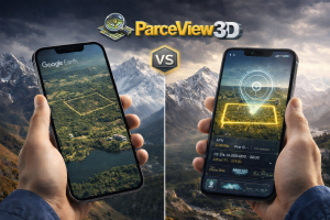
If you sell land for a living, you have probably heard of LandGlide. It is a popular mobile app for looking up parcel boundaries and owner information in the field. But when it comes to actually marketing a listing — getting buyers excited, generating inquiries, and closing deals — LandGlide was never built for that job. ParcelView3D was. This guide walks through how the two tools compare, where each one fits, and why land sellers and agents are increasingly choosing ParcelView3D as the centerpiece of their listing presentation.
The Short Answer
LandGlide is a parcel reference tool. ParcelView3D is a property marketing platform. They solve different problems for different moments in the land transaction lifecycle.
If you need to identify who owns a parcel while standing on a back road, LandGlide is a fine tool for that. If you need to present your listing in a way that converts online browsers into serious buyers, ParcelView3D is purpose-built for it. Most successful land sellers end up using both — but only one of them earns its keep on your listing pages, in your email campaigns, and across social media.
Two Different Workflows
LandGlide: Built for the Field
LandGlide is best known as a mobile companion for people who spend time on the ground — surveyors, foresters, hunters, and investors driving rural roads. Open the app, see the parcel you are standing on, look up the owner, and move on. It is fast, lightweight, and useful in that specific context.
What LandGlide does not do is help you market that parcel once you list it. There is no embeddable viewer for your website. No way to brand a property page with your logo. No inquiry capture, no shareable link a prospective buyer can forward to a spouse, and no path from “someone saw the listing” to “someone scheduled a showing.” That gap is exactly where ParcelView3D begins.
ParcelView3D: Built for the Listing
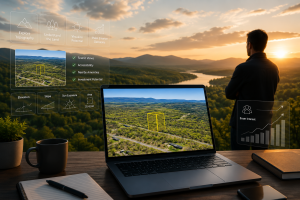
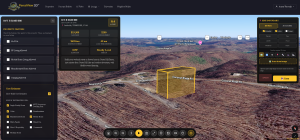
ParcelView3D was designed from day one for land sellers and agents who need to turn a parcel into a property — meaning a listing that is presented, branded, and marketed online. Every property in ParcelView3D becomes an interactive, immersive 3D experience that buyers can explore from any device, embedded directly on your website or shared as a clean link.
This matters because land is the hardest type of real estate to sell visually. A house has rooms you can photograph. A piece of land has terrain, access roads, treelines, water features, neighboring properties, and slopes that flat photos and basic boundary maps simply cannot communicate. ParcelView3D solves that problem.
Feature-by-Feature Comparison
The table below maps each tool against the features that matter when your goal is selling a piece of land — not just looking it up.
| Feature | ParcelView3D | LandGlide |
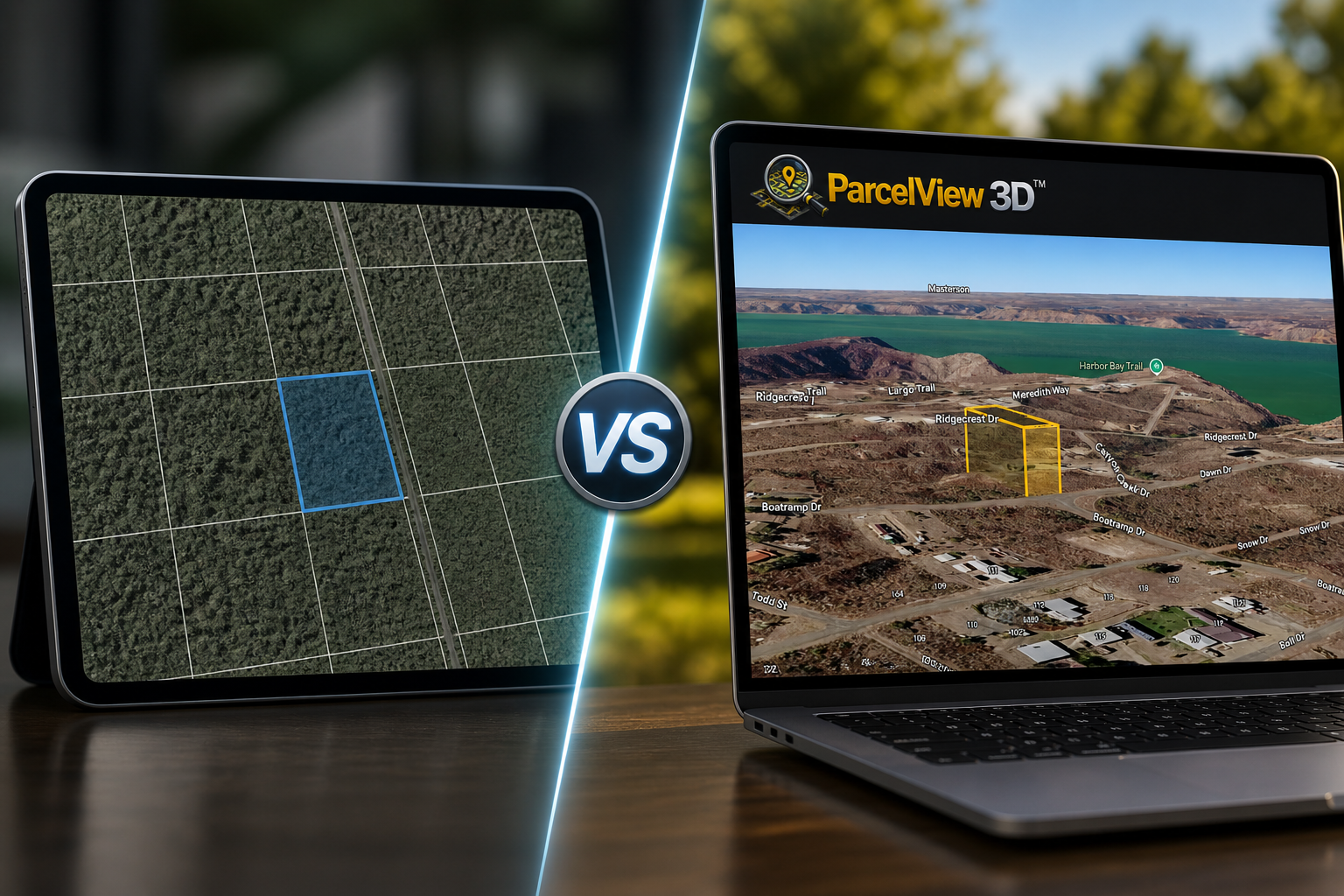
| Immersive 3D property views | Yes — interactive 3D environments built for every listing | No — flat parcel boundaries only |
| Embeddable on your website | Yes — drop-in embed for any listing page | No — mobile/desktop app only |
| Built for marketing listings | Yes — purpose-built for sellers and agents | No — designed for field reference |
| Custom property branding | Yes — your logo, colors, and branding bar | No |
| Property feature badges (RV, mobile homes, camping) | Yes — pill badges visible on every embed | No |
| Lead capture & inquiry forms | Yes — built-in inquiry capture per property | No |
| Shareable property links & QR codes | Yes — share-ready links for social, email, signage | Limited |
| Neighbor mailer / direct mail integration | Yes — click-to-select map and printed letters | No |
| Owner & parcel information lookup | Yes — included in every listing workflow | Yes — primary use case |
| Mobile-friendly viewer | Yes — responsive iframe viewer for buyers on any device | Yes — native mobile app |
| Pricing model | Plans starting free; paid tiers for marketing tools | Subscription required for full features |
| Best for | Land sellers and agents marketing properties online | Walking a property in the field |
Where ParcelView3D Wins for Land Sellers
1. Buyers Actually Engage With the Listing
A flat parcel outline on a generic map app does not sell land. An interactive 3D view that lets a buyer rotate the property, see how it sits relative to neighbors, and understand the terrain at a glance — that sells land. Sellers using ParcelView3D consistently report longer time-on-page, more inquiries per listing, and higher-quality leads, because the buyers who reach out have already explored the property and know what they are looking at.
2. Branding Stays on Your Property
When you send a buyer to a LandGlide screenshot or a generic mapping tool, the buyer sees that tool’s branding — not yours. ParcelView3D embeds carry your logo, your colors, and your property feature badges. Every time a prospect explores one of your listings, they are reinforced with your brand. Over the course of a year, that is the difference between being remembered and being one of a dozen forgettable links.
3. Embedded Right on Your Website
ParcelView3D was built to live inside your existing listing pages. Drop in a single embed code and your property page becomes interactive — no separate app for the buyer to download, no redirects to third-party tools that distract from your call to action. LandGlide has no embed option at all; it is a standalone app, period.
|
Buyer’s First Impression: Side by Side LANDGLIDE | PARCELVIEW3D ───────────────────────────── ───────────────────────────── Flat boundary outline | Immersive 3D environment Generic app branding | Your logo and colors No way to inquire | One-click inquiry capture App download required | Opens instantly in browser |
What a prospective buyer sees when they land on your property page.
4. Property Feature Badges Buyers Care About
Land buyers want to know the answers to specific questions before they ever pick up the phone. Can I park an RV here? Are mobile homes allowed? Is camping permitted? Is there a POA? ParcelView3D surfaces those answers as visible badges on every embed, so a buyer can self-qualify in seconds. LandGlide has no concept of property features — it shows boundaries and ownership, and that is the end of its scope.
5. Direct Mail and Neighbor Outreach
Selling land often means reaching the people most likely to buy it: the neighbors. ParcelView3D includes a click-to-select neighbor map and an integrated mail letter system that lets you generate, print, and send personalized outreach in a few minutes. Neighbors who receive the letter can scan a QR code and land on a 3D viewer of the exact parcel for sale. LandGlide offers nothing in this category.
6. Lead Capture That Closes the Loop
Every ParcelView3D embed includes a built-in inquiry form. A buyer who is interested can ask a question or request more information without leaving the listing — and that inquiry lands directly in your inbox, attached to the specific property. LandGlide has no buyer-facing inquiry workflow because it was never designed for that audience.
Where LandGlide Still Has a Place
None of this is to say LandGlide is a bad tool. It is genuinely useful for what it was built to do. If you are walking a property and want to confirm boundaries on your phone, LandGlide does the job. If you need a quick owner lookup while driving past a parcel that caught your eye, it is convenient. Many successful land professionals keep LandGlide installed for exactly these moments.
But none of those moments are the moment a buyer is deciding whether to inquire on your listing. That moment happens online, on your website or in a marketing email or on a social post. And in that moment, you need a tool built specifically for marketing land — not a field reference utility being asked to do a job it was never designed for.
The Real Question for Land Sellers
The honest question is not “LandGlide or ParcelView3D?” — it is “what does my listing presentation actually look like to a buyer right now?” If your current listing is a few photos, a flat boundary screenshot, and a description, you are leaving deals on the table. Buyers are comparing your property against dozens of others, and the listings that win are the listings that let them experience the land before they reach out.
ParcelView3D is the difference between a buyer who scrolls past your listing in five seconds and a buyer who spends two minutes exploring it, then sends you a message. Multiplied across every listing in your inventory, that gap is what separates sellers who consistently move land from sellers who watch their listings sit.
Quick Decision Guide
Choose ParcelView3D if you:
- Sell or list land and want buyers to see what they are buying
- Need branded, embeddable property pages on your own website
- Want lead capture and inquiry tracking built into every listing
- Run direct mail or neighbor outreach campaigns
- Care about how your brand looks across every property you market
Stick with LandGlide if you:
- Only need a field reference for boundary and owner lookups
- Are not actively marketing properties to buyers
- Do not need website embeds, branding, or lead capture
Most land professionals end up using ParcelView3D as their primary listing platform and keeping a parcel reference tool around for occasional field lookups. The two are complements, but only one of them moves your business forward.
|
Start Your Free Trial of ParcelView3D Turn every listing into an immersive experience buyers remember. No credit card required to get started — sign up in minutes and embed your first property today. Visit parcelview3d.com to claim your free trial. |
ParcelView3D — the listing platform built for the way land actually sells.