The Time-Killer Hiding in Your Inbox
If you sell land, you’ve answered this email a thousand times:
“Hey, just had a few more questions about the property. Is it flat or sloped? Does it sit in a low spot? Where would I actually put a house? Also, is there a creek on it? Thanks.”
Four topography questions. All things the buyer should have been able to answer themselves before they ever hit “send.”
Multiply that by 30 inbound inquiries a month and you’re burning 10+ hours a week typing the same answers, sending the same follow-up photos, and watching half those buyers ghost anyway — because the static images you sent didn’t actually answer their question.
This is the #1 time-killer in land sales. Not lead generation. Not contract negotiation. Topography Q&A. It’s the quiet, repetitive grind that eats your week, kills your deal velocity, and trains you to think land sales are slow by nature.
They’re not. The bottleneck is the format. And the fix is 3D.
Why Topography Q&A Eats So Much Time
Topography is the one thing every land buyer cares about — and the one thing a flat photo cannot communicate.
A top-down aerial photo flattens everything. A 50-foot grade change looks identical to a flat field. A pond looks the same as a depression that floods every spring. A buildable knoll looks the same as a slope you couldn’t park a trailer on.
So buyers ask. And ask. And ask. They email you, text you, call you, and message you on Facebook. They want the same six things from every property:
- Is it flat enough to use? Can I build, park an RV, put a barn, run cattle, plant a garden?
- How does the road approach it? Do I drive up to it, down to it, or across a wash?
- Where would the building pad realistically go? And is it big enough?
- Is any of it unusable? Cliffs, ravines, wetlands, drainage issues?
- Where does the water go? Does the lot drain or hold standing water?
- What am I looking at when I stand on it? Views, neighbors, tree coverage, ridge or valley?
Every email you answer about these six questions is unpaid customer service. Every minute you spend explaining slope on the phone is a minute you’re not acquiring inventory, building campaigns, or closing deals.
And the cruelest part: most of the buyers asking aren’t going to close anyway. You’re burning time on tire-kickers because they have no way to self-qualify.
The Fix: Make Topography Visually Self-Evident
The solution isn’t writing better listing descriptions. It’s making the topography so visually obvious that the buyer answers their own six questions before they even think to email you.
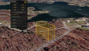
That’s what a 3D property view does. It shows the land the way the buyer would experience it if they were standing on it — actual terrain, actual slope, actual surrounding features, all rotatable and zoomable in the browser.
Unlike generic mapping tools built for street navigation or interior building tours, ParcelView3D was purpose-built for raw land. The experience is tuned for the questions that matter when there’s no structure on the property — terrain, slope, parcel context, and the buyer’s mental picture of standing on the lot. That focus is the difference between a tool that technically displays land and one that actually sells it.
This is exactly what ParcelView3D was built for. Add a property to your listing and the platform delivers a fully interactive 3D view — embeddable on your listing, shareable via SMS, viewable on any phone. The buyer rotates the view, tilts the camera, and answers all six topography questions in 30 seconds without ever opening their email client.
How a 3D View Answers All 6 Questions at Once
Here’s what’s actually happening in the buyer’s head when they open a 3D view of your property:
Question 1: Is it flat enough to use? The buyer tilts the camera to ground level and sees the slope of the lot in proportion to surrounding terrain. They know in 10 seconds whether they can build on it.
Question 2: How does the road approach it? The buyer follows the road into the parcel in 3D. They see whether the driveway climbs, drops, or runs flat — and whether the access point is on the high side or low side of the lot.
Question 3: Where would the building pad go? Flat areas are visually obvious in 3D. The buyer mentally places their structure on the largest flat zone without you having to explain anything.
Question 4: Is any of it unusable? Cliffs, ravines, and steep grades pop visually. So do low-lying areas that would clearly hold water. The buyer self-eliminates problem zones without asking you to walk them through it.
Question 5: Where does the water go? The natural high and low points are immediately visible. Buyers see where water would flow and which areas hold it.
Question 6: What does the view look like? A 3D walkthrough literally shows the view from the property — the ridgeline behind it, the trees, the neighboring parcels, the openness of the sky.
Six questions. One tool. Zero phone calls.
Going Deeper: The Topographic Contours Toggle
Most buyers get everything they need from the default 3D view. The terrain is obvious, the slope is obvious, the buildable areas are obvious — six questions, 30 seconds, done.
But some buyers want to go deeper. The buyer planning to pour a foundation cares about exact grade changes across the proposed pad. The buyer routing a driveway wants to see every rise and dip. The buyer placing a septic field needs to know which way the land actually falls.
For those buyers, ParcelView3D includes a Topographic Contours toggle built right into the Settings menu. One click and the 3D view layers visible contour lines across the parcel, showing exact elevation changes across the property — no surveyor, no GIS portal, no extra fee.
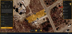
This is the kind of detail that used to require a surveyor visit, a county GIS portal, or a $200 topographic survey. Now it’s a checkbox — available to any buyer browsing your listing on their phone at 9pm.
And the smart part: it’s optional. Buyers who just want a quick look at the land never see contour lines cluttering the view. Buyers who want to evaluate the land like a builder can turn it on in one tap. The listing serves both audiences without compromise.
That’s another batch of phone calls you don’t have to take. The buyer who would have called and asked “what’s the actual grade across that flat area?” now answers the question themselves with one toggle.
How to Deploy 3D So It Actually Saves You Time
Most investors treat the 3D view as a bonus feature — something the buyer might click on if they’re curious. That’s backwards. To kill topography Q&A, 3D has to be the primary visual on every listing.
Here’s the deployment pattern that works:
- Lead with the 3D view, not a photo. The first thing the buyer sees on the listing page should be the interactive 3D model. Above the fold, on every property, no exceptions.
- Caption the obvious. Add short callouts under or beside the 3D view: “Flat 1.2 acres along the road frontage.” “Gentle slope down to the southern boundary.” “Building pad area: ~14,000 sq ft.” You’re not describing the topography — you’re confirming what the 3D view already shows.
- Use the 3D link as your first response to topography emails. When a buyer asks a topography question, don’t type a paragraph. Send the 3D link with one sentence: “Rotate it to the south view — you’ll see exactly what I mean about the buildable area.”
- Embed it in SMS and cold outreach. A buyer who opens a 3D link on their phone, rotates it on the spot, and forms a mental picture of the land is a buyer who’s three steps closer to signing than one who got a static photo.
- Make it the default in your follow-up sequences. Day 1 follow-up: the 3D link. Day 3 follow-up: the 3D link. Day 7: still the 3D link. The buyer’s mental model of the property gets stronger every time they open it.
What Happens to Your Business When You Fix This
Killing topography Q&A doesn’t just save you time. It compounds across your entire operation:
Your inbound volume drops, but your closing rate spikes. Fewer “just curious” emails. More “send me the contract” calls. The buyers who reach out are already qualified, because the unqualified ones eliminated themselves on the 3D view.
Your time-per-deal drops. You stop having the same 20-minute topography phone call three times a week. That time goes back into acquisition, marketing, and closing.
Your inventory turns faster. Properties that used to sit 90+ days move in 30. Properties that would have required a price cut sell at asking.
Your operation scales. The investor doing 5 deals a quarter manually answering topography emails can’t scale to 20 deals a quarter that way. The investor who’s automated the answer with 3D can.
The compounding effect is real. Every hour you save on topography Q&A is an hour reinvested in growth.
See the Fix in Action
The fastest way to understand the difference is to experience it yourself. Visit parcelview3d.com and open a live 3D property view. Rotate it. Tilt it. Zoom in on a specific corner of the parcel. Pretend you’re a buyer in another state who’s never seen this land before.
In 30 seconds you’ll know — visually, intuitively, without anyone explaining it — every topography fact about that property. That’s the exact experience your buyers should be having on every one of your listings.
The Bottom Line
Topography Q&A is the #1 time-killer in land sales — and unlike most operational drags, it has a clean fix. 3D property views answer all six core topography questions in a single visual experience, before the buyer asks, before they email you, before they ghost.
Stop typing the same answers every week. Let your listing answer them once, in 3D, for every buyer who lands on it.
Try a live 3D property view at parcelview3d.com and see what your listings should look like.