Buying vacant land can be an exciting investment opportunity, but it also comes with unique challenges. Unlike traditional residential real estate, vacant land does not always provide buyers with obvious visual cues about the property. A parcel may appear attractive in photos, yet hidden issues such as steep terrain, poor access roads, flood-prone areas, or neighboring developments can dramatically affect its value and usability.
This is why due diligence is one of the most important steps in the land-buying process. Buyers need to verify boundaries, understand the terrain, evaluate access, check nearby infrastructure, and confirm whether the property aligns with their intended use. Traditionally, this process required extensive research across multiple websites, county records, and mapping platforms.
Today, advanced interactive property visualization technology is transforming how buyers evaluate vacant land. interactive property views allow buyers to explore properties remotely, visualize terrain and elevation, inspect road access, and better understand the surrounding area before making a purchase decision. For out-of-state investors and first-time land buyers, these tools simplify the research process and reduce uncertainty.
In this article, we’ll explore how interactive property visualization tools simplify due diligence for vacant land buyers and why they have become an essential tool in modern land investing.
What Is Due Diligence in Vacant Land?
Due diligence refers to the process of researching and verifying important details about a property before purchasing it. For vacant land buyers, due diligence helps uncover potential issues and confirms whether the land is suitable for their intended goals.
Key due diligence factors include:
• Verifying property boundaries
• Confirming legal access
• Understanding elevation and terrain
• Reviewing flood zones and drainage
• Checking utility availability
• Evaluating zoning and restrictions
• Researching nearby developments and amenities
Without proper due diligence, buyers may face costly surprises after purchase. Fortunately, interactive property visualization tools make many of these research tasks faster and easier.
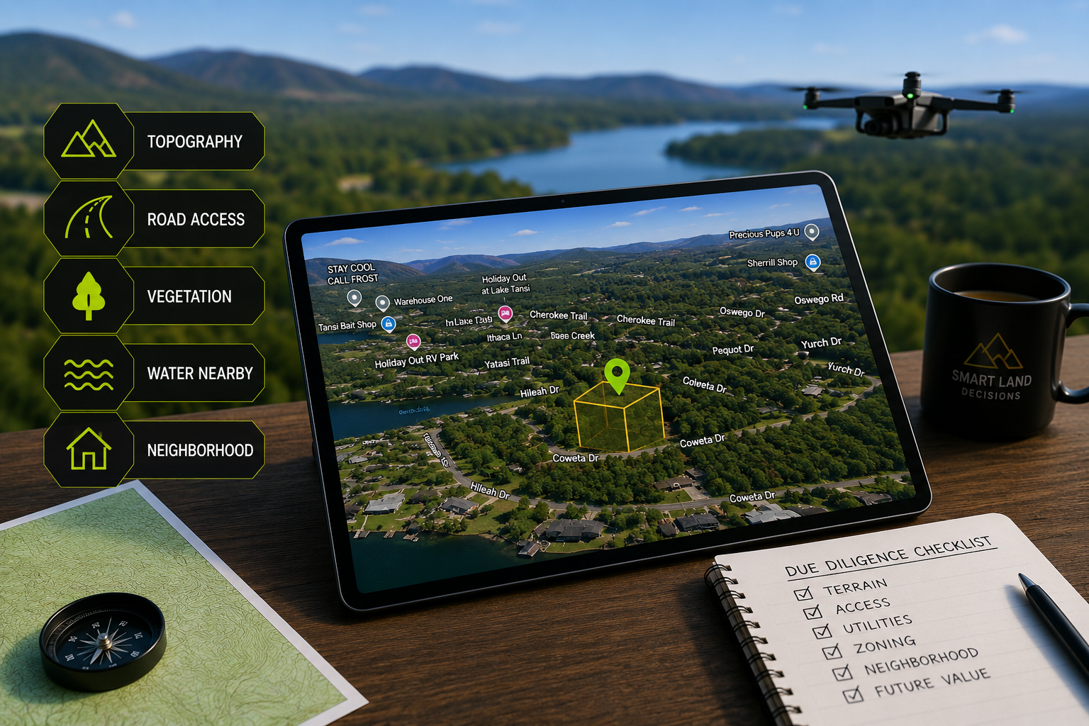
Visualizing Terrain and Elevation
One of the biggest advantages of advanced interactive property visualization technology is the ability to understand terrain and elevation instantly. Traditional property photos often fail to show whether a property is flat, sloped, wooded, or uneven.
With interactive interactive property visualization tools, buyers can rotate the map, zoom in, and explore the property from multiple angles. This helps identify:
• Hills and elevation changes
• Flat buildable areas
• Drainage paths
• Potential flood concerns
• Rocky or difficult terrain
For buyers planning to build a home, park an RV, or develop recreational property, understanding terrain is critical. A 3D map gives a much clearer picture than flat property imagery alone.
Understanding Road Access and Entry Points
Access is another major concern for vacant land buyers. Some properties may appear accessible on paper but have difficult roads, private easements, or undeveloped paths leading to the parcel.
interactive property visualization tools help buyers:
• Identify paved vs. dirt roads
• Evaluate road conditions visually
• Locate entrances and nearby intersections
• Understand surrounding infrastructure
• Measure proximity to towns and services
This is especially important for rural properties where road conditions can significantly impact usability and resale value.
Seeing Nearby Development and Neighborhood Features
Vacant land buyers often want to understand what surrounds the property. Is the area rural and secluded? Are there nearby homes? Is the neighborhood growing?
interactive property views allow buyers to inspect nearby development patterns and community features such as:
• Residential neighborhoods
• Lakes and recreation areas
• Commercial developments
• Parks and public land
• Nearby utilities and structures
This information helps buyers determine whether the property matches their long-term investment goals or lifestyle preferences.
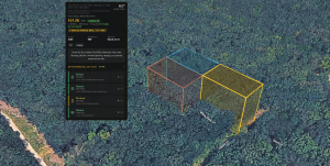
Comparing 3D Maps to Traditional Property Photos
Traditional listing photos are useful, but they only provide limited perspectives. A few aerial images may not fully explain the property’s layout, slope, or surrounding area.
interactive property visualization tools improve transparency because buyers can:
• Explore the entire property interactively
• Rotate the terrain from different angles
• Zoom in on roads and nearby structures
• View elevation changes clearly
• Understand proximity to lakes, towns, and highways
This interactive experience gives buyers more confidence during the decision-making process.
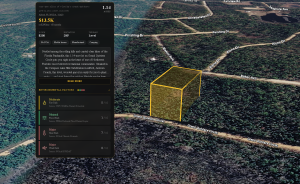
Example: Evaluating a Vacant Land Listing with 3D Maps
Imagine a buyer researching a wooded property in Crossville, Tennessee. A standard listing may include photos of trees and a short description, but a 3D map reveals much more.
Using a 3D property map, the buyer can quickly determine:
• Whether the lot is heavily sloped or mostly level
• The condition of nearby roads
• Proximity to neighboring homes
• Access to nearby lakes and recreation areas
• Terrain suitable for building
This allows the buyer to complete much of their initial due diligence remotely before ever visiting the property in person.
Benefits for Out-of-State Land Buyers
Many vacant land buyers purchase property remotely, especially investors looking for recreational or long-term investment opportunities. Traveling to every property can be expensive and time-consuming.
interactive property visualization tools provide major benefits for remote buyers:
• Reduce the need for unnecessary travel
• Improve confidence in online listings
• Simplify property comparisons
• Speed up decision-making
• Improve transparency during the buying process
For owner-financed land buyers, interactive maps help build trust and reduce uncertainty.
How Gateway Land Investments Uses 3D Maps
Gateway Land Investments incorporates interactive property visuals, GPS coordinates, and interactive map links into property listings to help buyers perform better due diligence.
Many Gateway property reports include:
• Interactive map links
• GPS coordinates
• Terrain details
• Nearby amenities
• Property access information
• Utility availability
These tools help buyers evaluate properties remotely and make informed purchasing decisions.
Example Demo Property:
https://gatewaylandinvestments.com/Property/430173237-0-23-acres-561-royal-dr-n-bullard-tx-75757/
Conclusion
advanced interactive property visualization technology is changing the way buyers research and purchase vacant land. By simplifying terrain analysis, road access evaluation, and neighborhood research, interactive maps reduce uncertainty and improve buyer confidence.
Whether purchasing recreational property, investment land, or a future homesite, buyers can use interactive property visualization tools to perform faster and more effective due diligence. As land investing continues to move online, interactive mapping tools will play an even larger role in helping buyers make informed decisions.
For anyone researching vacant land remotely, interactive property visualization tools are no longer just a helpful feature — they are becoming an essential part of the modern land-buying process.
Demo Property Links
https://gatewaylandinvestments.com/Property/430173237-0-23-acres-561-royal-dr-n-bullard-tx-75757/
Why Buyers Prefer ParcelView3D
ParcelView3D helps simplify the land research process by providing a cleaner and more user-friendly property viewing experience for vacant land buyers. Compared to traditional listing platforms that rely heavily on static images and limited property details, ParcelView3D gives buyers a more immersive way to evaluate land remotely.
Buyers can better understand:
• Terrain and buildable areas
• Road access and surrounding infrastructure
• Nearby lakes, towns, and amenities
• Property layout and visibility
• Overall usability of the parcel
This improved visualization experience helps buyers make faster and more confident decisions while reducing uncertainty during the due diligence process.