If you sell land, you already know the math: the same parcel listed on a major real estate website and on ParcelView3D will perform very differently — not because the land is different, but because what the buyer can actually see is different. Most real estate sites were built for houses. ParcelView3D was built for land. This guide breaks down exactly what buyers miss when a parcel is presented in the traditional way, and why an interactive 3D experience consistently moves them from “curious” to “qualified.”
The Gap Between What Buyers See and What They Need to Know
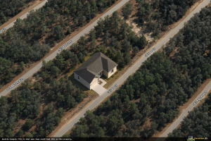
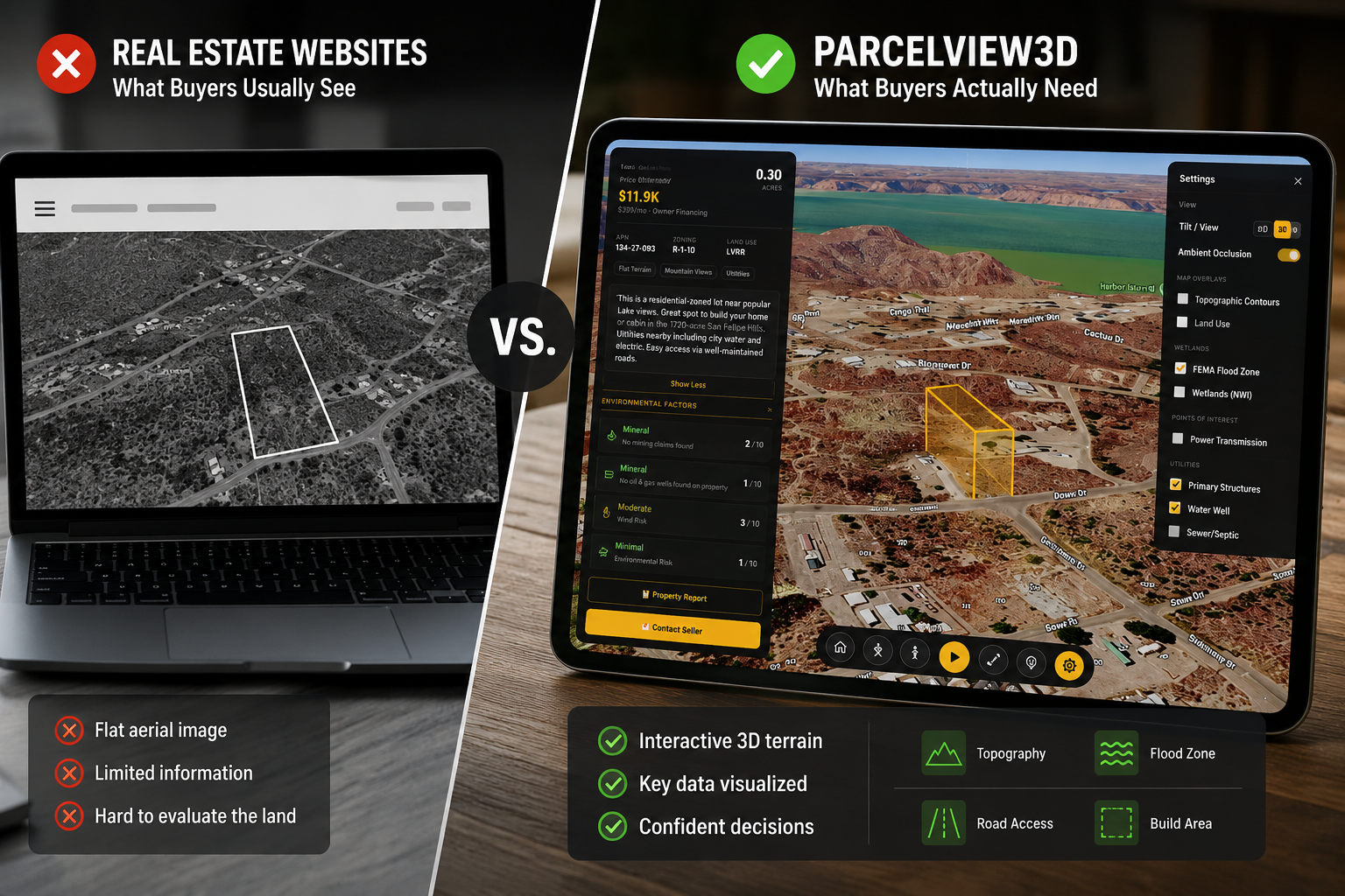
Real estate websites are excellent at one thing: showing buyers the inside of a house. Twenty photos, a floor plan, a walkthrough video, school ratings, and a price — that’s a complete picture when there’s a structure to walk through. Land is the opposite. There is no kitchen to photograph. There is no living room angle. There is just terrain, trees, road frontage, water, soil, and possibility. A buyer looking at a vacant parcel on a typical national listing site is essentially looking at a blurry rectangle outlined on a flat aerial photo, with a price and one or two paragraphs of description. Everything that matters — slope, drainage, build feasibility, the feel of standing on the property — is invisible.
That gap is why land sells slower than houses, why buyers ghost listings after one email, and why sellers end up driving out to the parcel for a showing that ends in “I’ll think about it.” The buyer never had enough information to make a decision in the first place.
What Buyers Miss on Traditional Real Estate Websites
When a land listing only contains a flat satellite image and a text description, the buyer is forced to make assumptions. Those assumptions almost always lead to one of three outcomes: they overlook a good parcel because it looks bland, they get excited about a parcel and then walk away after discovering an issue the listing should have surfaced, or they simply move on without ever contacting the seller. Here’s what a typical land buyer cannot tell from a traditional listing:
- Topography and slope. A flat aerial photo gives no sense of elevation change. Is the back half of the lot a gentle rise or a steep drop into a ravine? You can’t tell.
- Real road frontage. The listing might say “road access,” but the buyer can’t see how the frontage actually meets the road, whether it’s paved, or how much of the boundary touches it.
- Flood and wetlands. Most national real estate sites bury flood zone data — if they show it at all — behind a separate tab or external link. Wetlands are almost never shown.
- Build feasibility. Can a home be sited here? Where would the well and septic go? What would the total investment look like? Buyers have to call a builder to even get a ballpark.
- True scale. Ten acres looks the same as five on a thumbnail. Buyers don’t get a feel for how much land they’re actually looking at until they’re standing on it.
- The emotional pull. Land sells on feeling. Flat photos kill the feeling. Without a way to fly the parcel, buyers don’t fall in love with it.
The result is predictable. Buyers who can’t see these things either project their fears onto the parcel (“probably swampy, probably steep, probably hard to build on”) or simply scroll past. The seller never gets the lead.
How ParcelView3D Closes the Gap
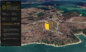
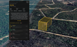
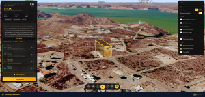
ParcelView3D was built by land investors for land investors. Instead of forcing a parcel into a house-shaped template, it turns every listing into an interactive 3D experience the buyer can fly around, tilt, and explore. Within the first few seconds on the page, the buyer sees the actual terrain, the actual boundary drawn in 3D over the actual land, and the actual context — neighboring properties, road access, water features, tree cover. They stop guessing and start evaluating.
Better still, the things buyers usually have to chase down — flood risk, wetlands, slope, build cost — are surfaced right on the same screen. The viewer comes with toggleable overlays for topography, flood zones, wetlands, soil, and other layers that matter to land buyers. An AI build cost estimator gives buyers a credible range for what it would cost to put a single-family home, cabin, or manufactured home on the parcel, including well, septic, and site prep. Suddenly the conversation shifts from “is this a good piece of land?” to “how do I make an offer?”
Feature Comparison
Here’s a side-by-side of what a buyer (and a seller) actually gets from each experience.
| Feature | Traditional Real Estate Websites | ParcelView3D |
| True 3D terrain & elevation | Flat aerial photo only | Photorealistic 3D with real terrain |
| Property boundary visualization | Static map outline | Boundary drawn in 3D over real land |
| Topography & slope analysis | Not shown | On-screen overlay, toggleable |
| Flood zone overlay | External link, if any | Built into the 3D view |
| Wetlands & soil data | Not shown | On-screen overlay, toggleable |
| Road frontage measurement | Mentioned in text only | Visible & measured on the viewer |
| Build cost estimate | Buyer must call a builder | AI estimator built into the listing |
| Well & septic feasibility | Buyer must research separately | Shown on the listing card |
| Cinematic flyover video | Static photos | Auto-generated property flyovers |
| AI concept renderings | Not available | Photorealistic concept images on the parcel |
| Embed on your own site | No (closed marketplace) | One-line embed, anywhere |
| Branded storefront | Listing lives on their domain | Your logo, your colors, your domain |
| Direct CRM lead sync | Limited or none | Pushes leads to your CRM automatically |
| QR codes for offline use | Not native | Print-ready QR for signs and flyers |
| Listing analytics for sellers | Basic view counts | Time-on-page, return visits, lead quality |
It’s Not Just a Better Listing — It’s a Better Funnel
Traditional real estate sites keep the listing on their platform. The buyer browses other parcels — including the competition’s — before they ever contact the seller. ParcelView3D flips that. Every property gets its own shareable landing page (a PropCard) with the 3D viewer, photos, concept renderings, video, pricing, and a built-in lead form. That page can be embedded on the seller’s own website, printed as a QR code on a yard sign, dropped into an email blast, or pushed out to a national listing marketplace with a single click. Wherever the buyer first encounters the parcel, the experience is the same: interactive, complete, and branded to the seller — not to a third-party portal.
Figure 3 — One interactive listing, every channel. The same 3D experience travels with the parcel wherever the seller markets it.
What This Means for Time on Market
The numbers from land investors using ParcelView3D are consistent: buyers spend several minutes on a 3D listing instead of seconds on a flat one, qualified-lead rates climb meaningfully, and parcels move noticeably faster. Part of that is informational — buyers no longer need to email and ask “is it in the flood plain” or “is there road access” because they can see the answers for themselves. Part of it is emotional — a buyer who has flown the parcel three times and zoomed in on the tree cover is already invested. By the time they fill out the lead form, they’re not asking whether to buy. They’re asking how soon they can.
Sellers, meanwhile, get a level of feedback that’s impossible to extract from a traditional listing. ParcelView3D shows which properties are getting views, how long buyers are spending on each one, which parcels are being revisited, and which leads came in warm. That makes follow-up dramatically more efficient: instead of cold-calling everyone in the inbox, the seller can call the buyer who flew the parcel four times yesterday.
The Takeaway
National real estate websites are great if you’re selling a house. For raw land, they were never built to answer the questions buyers actually ask. ParcelView3D was. The platform closes the information gap, replaces flat photos with an experience buyers can touch and explore, and gives sellers a marketing engine — embeddable, brandable, shareable — that travels with every parcel they list. The result is the same parcel, sold faster, at a stronger price, with fewer back-and-forth emails along the way.
Try it on your next listing. The 7-day trial is genuinely free, no card required, up to three properties at a time. If a single buyer doesn’t spend more time on your 3D listing than they have on any flat one, walk away. Most sellers don’t.
Learn more at parcelview3d.com