While most of the proptech conversation centers on luxury condos, residential walkthroughs, and glossy urban developments, a much quieter revolution has been unfolding in the rural land investment market. Land investors, owner-financed sellers, and dispositions teams are discovering something that residential agents figured out a decade ago: buyers don’t buy what they can’t visualize. And for raw land — where there’s nothing to walk through, no staging, no curb appeal — that problem has historically been the single biggest friction point in the entire industry.
That friction is starting to disappear. And the shift is happening faster than most people in the space realize.
The Old Playbook Is Breaking Down
For most of the last 30 years, the rural land disposition playbook looked roughly the same: pull a parcel map, grab an aerial screenshot, snap a few photos from the road (if you could even find the road), post to Facebook Marketplace and a handful of land listing sites, then wait. Maybe run a cold call campaign to neighbors. Maybe send postcards. Then wait some more.
The average time-on-market for rural land in many parts of the country still stretches into 6-to-12-month territory — not because the demand isn’t there, but because buyers simply can’t picture what they’re looking at. A flat aerial photo of 40 acres of Tennessee scrubland looks indistinguishable from 40 acres of Oklahoma grassland or 40 acres of Florida palmetto. The buyer has no sense of terrain, slope, buildability, access, or what the property could actually become.
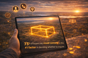
The data on listing engagement tells the story clearly. Listings with interactive or immersive visuals consistently outperform static-image listings on nearly every metric that matters to a disposition team: time-on-page, inquiry rate, and contract velocity. For residential real estate, the industry accepted this reality years ago — which is why virtual tours are now standard. For rural land, the tools simply didn’t exist at an accessible price point. Until recently.
Why Rural Land is Different (And Harder)
Here’s the thing residential proptech companies have never really solved for: rural land has no interior. You can’t do a walkthrough of a pasture. There’s no kitchen to photograph, no finishes to show off. The “product” is topography, soil, trees, water, access, zoning potential, and whatever the buyer’s imagination can conjure about what they’d build there.
That’s an enormous cognitive load to place on a buyer — and most of them aren’t equipped to carry it. A retiree looking for a place to put a cabin in the Smokies doesn’t know how to read a topographic map. A first-time land buyer looking at 5 acres in Texas hill country can’t tell from a flat aerial image whether the buildable area has the right setbacks for the septic system they’d need. An investor evaluating a tract for subdivision potential can’t eyeball flood zones, easements, and elevation changes from a still image.
The result? Buyers hesitate. Deals stall. Sellers drop price. Everyone loses.
What 3D Visualization Actually Changes
When you give a rural land buyer a real 3D view of the property — one they can orbit, tilt, zoom, and explore — something shifts almost immediately. They stop asking “where exactly is this?” and start asking “what could I do with it?” That’s the emotional pivot that moves a piece of land from the “I’ll think about it” pile into the “let’s do this” pile.
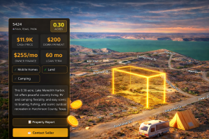
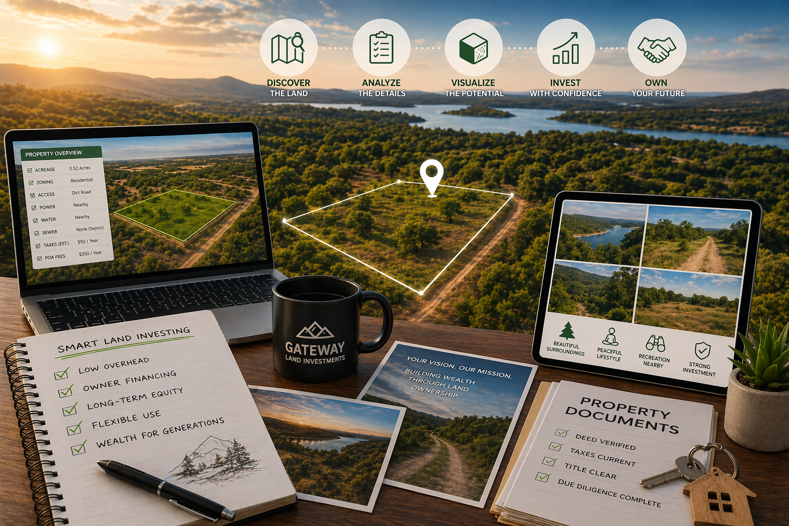
Modern platforms like ParcelView3D have built the infrastructure specifically for this use case. Rather than retrofitting residential tools for land, PV3D starts from the premise that land is the whole story. Buyers get a photorealistic, interactive 3D experience of the parcel — the slopes, the tree coverage, the access road, the neighboring parcels, the way the light falls on the property in the afternoon. It’s the difference between reading a menu and being handed a plate of food.
But the 3D view is just the starting point. The bigger unlock is what comes next.
From “What Is It?” to “What Could It Be?”
The real magic in modern land visualization isn’t showing buyers what the property is — it’s showing them what it could become.
This is where AI concept rendering has quietly moved from novelty to table stakes. Tools that place photorealistic homes, cabins, ADUs, barns, or RV setups directly onto the real imagery of a specific parcel are transforming how land is marketed. Instead of asking a buyer to imagine a 1,200-square-foot cabin tucked into the tree line on Lot 7, the seller just… shows them. In the actual location. On the actual terrain. Before a single shovel hits the ground.
PV3D’s AI concept rendering and cinematic flyover features are built exactly for this moment. A seller can generate a photorealistic image of a modest cabin on a wooded lot, a manufactured home on a cleared pad, or a full ADU buildout with landscaping — all placed onto the real imagery of the parcel being sold. Pair that with a 10-second cinematic flyover video, and suddenly the listing is doing something a simple aerial photo never could: it’s telling a story.
This matters enormously in the owner-financed land segment, where buyers are often first-time land owners making an emotional purchase based on a dream. Helping them see the dream isn’t a gimmick. It’s the entire job of a disposition team.
The Build Cost Problem (And Why It’s Been Quietly Killing Deals)
Here’s something that rarely gets discussed in land investment circles but costs the industry millions in lost sales every year: buyers can’t do the math. They see a $25,000 lot and have no idea if they can actually afford to build on it. They don’t know what a well costs in that county. They don’t know if the soil will perc for septic. They don’t know what site prep runs in that region. So they freeze — and the deal dies not because the land is wrong, but because the buyer couldn’t picture the full financial picture.
This is one of the more subtle shifts happening in the space right now. Platforms are starting to bake cost intelligence directly into the listing itself. ParcelView3D’s AI Build Cost Estimator analyzes well feasibility, septic suitability, and regional build costs for the structure itself — then serves the buyer a ballpark total investment number right on the property card. Land + build + site prep, all in one view.
For a disposition team, that’s a quiet game-changer. You’re no longer just selling land. You’re selling a pathway.
Shareable, Mobile-First, and Built for How Land Actually Sells
One of the most practical shifts in the rural land market is that a huge percentage of lookers are browsing on their phones, often from a truck, often after seeing a yard sign or a Facebook post. The tools that are winning right now aren’t the ones with the fanciest desktop dashboards — they’re the ones optimized for the buyer leaning against their F-150 at 7pm scrolling through listings.
PV3D’s PropCards approach leans hard into this reality. Every property gets a mobile-first landing page with the 3D viewer, concept images, videos, pricing, and a built-in lead capture form — all behind a single shareable link. QR codes make the jump from yard sign to mobile listing seamless. That’s a small operational detail that matters enormously for the drive-by traffic that still drives a big chunk of rural land inquiries.
What’s Coming Next
The rural land market is famously slow to adopt new technology — which is exactly why the sellers adopting these tools right now are quietly crushing the market. When everyone else is still posting aerial screenshots to Craigslist, the seller with 3D viewers, AI concepts, cost estimates, and shareable PropCards is operating on a different level entirely.
Expect to see three things accelerate over the next 12-24 months: wider adoption of 3D visualization as a standard (not a premium) listing feature; tighter integration between visualization tools and the actual transaction stack (CRMs, e-sign, payment); and a quiet sorting of the market into sellers who adapted and sellers who didn’t.
For land investors willing to move early, the window is still wide open. The buyers are already there. They’re just waiting to be shown what they can’t yet see.
Want to see how 3D visualization changes the way your listings convert? Start a free trial of ParcelView3D — or explore more on https://parcelview3d.com/why-3d-property-visualization-is-replacing-static-maps-in-land-sales/ and https://parcelview3d.com/how-to-show-buyers-what-their-future-looks-like-on-a-piece-of-land/.