Land buyers don’t buy dirt — they buy a future. Here’s why visualization is the single biggest lever in land sales, and how modern tools let you put the dream directly in front of them.
Nobody Buys Land. They Buy What It Could Become.
Here’s a truth every experienced land seller eventually learns the hard way: people don’t buy land for what it is. They buy it for what it could become.
A vacant 5-acre parcel isn’t a 5-acre parcel to the buyer. It’s a cabin by the creek. It’s the homestead they’ve been dreaming about since they were 22. It’s a retirement workshop. It’s a short-term rental that pays for itself. It’s the place their grandkids will run around in the summer.
And here’s the problem: nothing in a standard land listing helps the buyer see any of that.
A flat aerial photo shows them dirt and trees. A plat map shows them lines. A written description tells them acreage and road frontage. None of that reaches the part of the brain that actually makes a buying decision. That part — the part that turns a maybe into a yes — needs to picture the future before it can commit to it.
This is why most land sits on the market for 6 to 12 months while the sellers who’ve figured out visualization are closing in weeks. The dirt hasn’t changed. The price hasn’t necessarily changed. What’s changed is whether the buyer can see themselves on it.
Showing buyers their future is the entire game. Here’s how to do it.
Why the Brain Needs to See It Before It Will Buy It
There’s a reason every new home development builds a model home. There’s a reason car dealers hand you the keys for a test drive. There’s a reason Airbnb shows you 40 photos of every listing. Humans are visual, spatial, emotional creatures — we make decisions with the image-forming part of the brain and then justify them later with logic.
Land sales have historically ignored this. Instead of giving buyers a model to stand inside, sellers hand them a PDF and say “use your imagination.” Most buyers can’t. Or won’t. They scroll past, click to the next listing, and you never hear from them again.
The sellers closing the most deals right now aren’t better negotiators. They’ve just stopped asking buyers to imagine. They’re showing them.
There are four specific things a modern land listing needs to show a buyer to get them emotionally committed — and each one corresponds to a question the buyer is silently asking.
What to Show (And What Each Thing Answers)
1. The Land Itself — In Three Dimensions
The silent question: “What is this place actually like?”
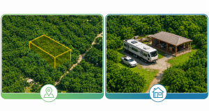
Flat photos flatten everything. A gentle slope and a cliff can look identical from above. A property tucked into mature hardwoods looks the same as a scrubby clear-cut if the drone was at the wrong angle. Buyers know this, which is why they don’t trust photos alone.
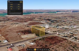
A 3D view of the parcel — real terrain, real satellite imagery, real parcel boundaries — tells the buyer what the land feels like. They can fly over it, rotate around it, zoom in on the corner where the creek bends. For the first time, they’re not looking at a picture of the land. They’re at the land.
This is the single biggest shift in land marketing in the last decade. Buyers who spend three minutes exploring a 3D view of a parcel are fundamentally different leads than buyers who glanced at six photos. They’ve already started to own it in their head.
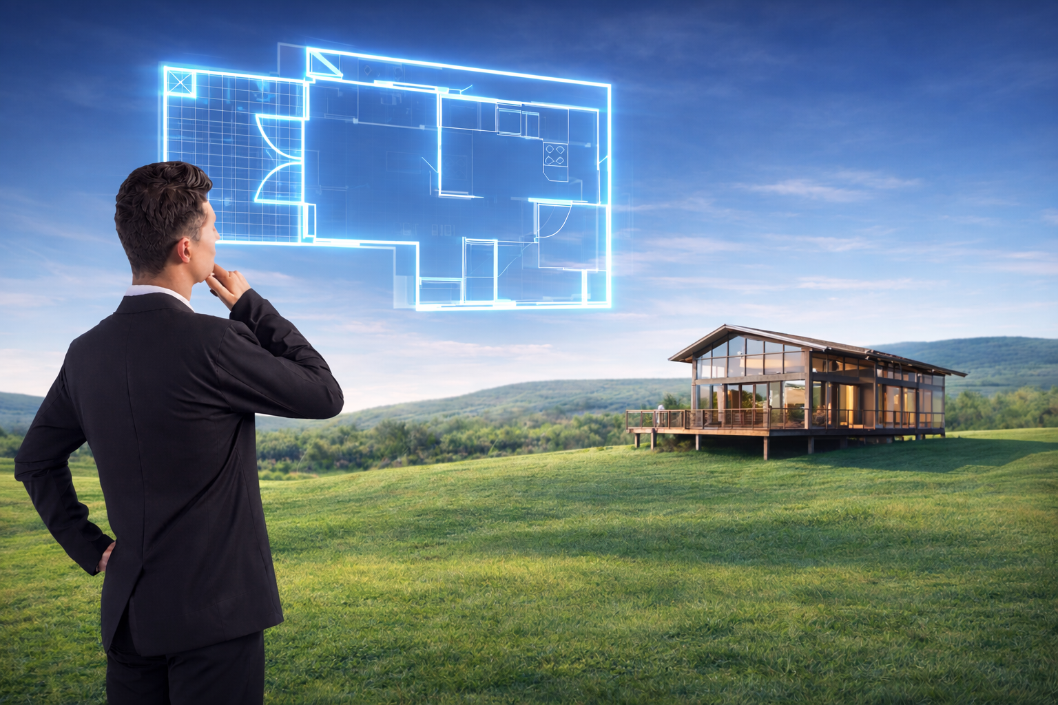
2. What Could Be Built There
The silent question: “Could I actually build what I’m picturing?”
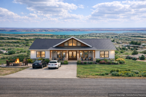
Every serious land buyer has a picture in their head — a cabin, a tiny home, a barndominium, a retirement ranch, a spec house, an RV pad. That picture is the reason they’re shopping for land in the first place. And their biggest fear, the one that kills most deals, is that their picture won’t actually fit on this piece of land.
Show them that it will.
AI-generated concept renderings let you drop a realistic structure onto the specific parcel and show the buyer exactly what their dream looks like in place. Not a generic stock photo of a log cabin. A render of their cabin on their lot, with the actual tree line, the actual road frontage, the actual terrain behind it.
The moment a buyer sees that image, something changes. The listing stops being “a piece of land I’m considering” and becomes “the place I’m going to live.” That’s an emotional shift you can’t manufacture with better copywriting.
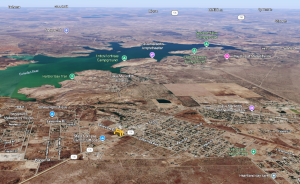
3. What’s Around It
The silent question: “Am I going to feel isolated? Or hemmed in?”
Rural land buyers have two opposite fears, and they’re both real. Some buyers worry they’ll be so remote they can’t get groceries. Others worry they’ll buy “rural” land and end up with a subdivision going up across the road in two years. Both fears kill deals silently.
Context views solve this. Buyers need to see the road access, the distance to the nearest town, the neighboring properties, the power lines, the tree buffer, the terrain features that make the property feel private or exposed. Street-level and ground-level views let them stand at the property line, virtually, and look out in every direction.
When a buyer can see the context, they stop guessing and start planning. The listing starts answering questions instead of raising them.
4. The Future, Not Just the Present
The silent question: “Can I see myself here?”
This is the one that closes the sale. Everything else is table stakes. The final visualization — the one that turns an interested lead into a signed contract — is the image of the buyer’s life on that land.
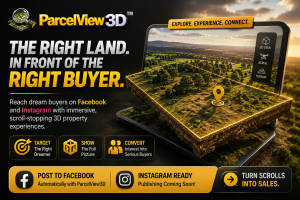
That’s where concept videos come in. A 60-second video showing a family on the dock, a truck pulling into the gravel driveway at sunset, a firepit in the clearing, a barn under construction — that’s not a listing. That’s a memory the buyer hasn’t made yet. And if you plant it in their head before they close the tab, they’ll come back to make it real.
This is why property videos consistently outperform photo-only listings by 3–5x in ad click-through rates. Video doesn’t just show the land — it shows the life on the land. And that’s what the buyer is actually shopping for.
A Quick Reality Check: This Used to Be Impossible
Five years ago, showing a buyer their future on a specific piece of land required a $15,000 architectural rendering, a week of back-and-forth with a designer, and a property under contract before you’d even spend the money. It wasn’t viable for a land investor listing 30 properties a year. It was barely viable for developers on multi-million-dollar projects.
That’s not true anymore.
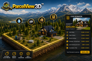
AI rendering has collapsed the cost and time of creating those visuals from weeks to minutes. Modern 3D mapping platforms pull real parcel data and terrain directly from public sources. Site planning tools let sellers place buildings on land with a few clicks. The technology stack that used to require a six-figure software license is now a single SaaS subscription.
This is why the sellers who adopt these tools in 2026 are pulling so far ahead of everyone else. The tools finally exist. The question is just whether you’re using them.
Putting It Together: What a Modern Land Listing Looks Like
Imagine two listings for the same 5-acre lot, side by side.
Listing A has 12 drone photos, a plat map, a Google satellite screenshot, and a 300-word description. It’s priced right. It’s been on the market for seven months.
Listing B has an embedded interactive 3D viewer where buyers can fly over the property. It has four AI-generated concept images showing a cabin, a tiny home, a small barn with a workshop, and an RV pad setup — all rendered on the actual lot. It has a 60-second video tour used in Facebook ads. It has a ground-view panorama from the road. It has an interactive site planner where the buyer can drop a building where they’d want it.
The buyer hits Listing A and scrolls past in 15 seconds.
The buyer hits Listing B, spends five minutes exploring, mentally places their cabin near the creek, imagines the driveway curving up from the road, and opens the contact form.
That’s not hypothetical. That’s what the data from modern 3D listings actually shows. And it’s the difference between a property that sits for a year and one that sells in three weeks.

Side-by-side comparison — flat aerial listing vs. PV3D
See It Working (Request a Demo)
The fastest way to understand this is to see it applied to land you know — a listing you’re working on, a parcel you’re considering, or a property in your portfolio. ParcelView3D offers personal demos where we walk you through the 3D viewer, AI concept renderings, and property video output using a real parcel, and show you exactly how the embed looks on a listing page.
→ Request a demo at parcelview3d.com
In the demo, we’ll show you:
- An interactive 3D flyover of a real parcel with full terrain and satellite imagery
- Aerial, ground, and street-level views of the property
- AI-generated building concepts rendered directly on the lot
- The interactive site planner for placing structures on the land
- A 60-second property video of the kind used in social and paid ads
- Exactly what a buyer sees when they land on a listing using the PV3D embed
It takes about 20 minutes, and it’s the fastest way to understand why this approach is shifting the entire land sales market.
The Shift Is Already Happening
Land marketing is undergoing the same shift that residential real estate went through 15 years ago, when Zillow and professional photography separated the listings that sold fast from the ones that sat. The sellers who adapted early pulled ahead and never looked back. The ones who insisted on film photos and newspaper ads got left behind.
We’re at that same moment in land. Right now, most listings are still stuck in the old paradigm — flat photos, plat maps, paragraphs of text, and a hope that the buyer’s imagination will do the heavy lifting. It won’t.
But the tools to do it properly are finally here, finally affordable, and finally fast enough to use on every listing you put up. There’s no reason to ask buyers to imagine their future on your land when you can show it to them instead.
The best land listing isn’t the one with the most acreage, the best price, or the prettiest aerial shot. It’s the one where the buyer closes the tab and can’t stop thinking about the life they just saw themselves living.
Go show them.
Ready to show your buyers their future? Request a demo of ParcelView3D and see how your next listing could look.