Most land sellers think they have a traffic problem. They don’t. They have a trust problem — and here’s exactly how to fix it.
The Real Reason Buyers Go Silent
You know the scenario: a buyer sends an inquiry, asks a few questions, you respond quickly. Then nothing. They ghost you.
It wasn’t the price. It wasn’t the location. It was the listing — or rather, what the listing couldn’t show them.
Land buyers carry a mental checklist of concerns they almost never voice out loud. When your listing can’t answer these questions, they don’t ask. They move on.
- Is this land actually flat enough to build on, or all slopes and ravines?
- Can I get a truck in there — or does that road wash out every spring?
- What does flood risk actually look like on this parcel?
- Can I park an RV here? Run cattle? Put up a cabin?
- Does this land have a sense of place, or is it just a blank rectangle on a map?
Traditional listings answer almost none of these questions. A few aerial shots, a county parcel overlay, and boilerplate copy — none of that builds the confidence a buyer needs to pick up the phone.
What Poor Listing Presentation Actually Costs You
The Time-on-Market Trap
Every extra month your property sits is money out of your pocket — not just from missed proceeds, but from direct holding costs:
- Property taxes: $500–$3,000+ annually
- Insurance: $300–$1,500+ annually
- Opportunity cost: capital sitting idle instead of working
- Maintenance: access roads, signage, site visits
Example: A $60,000 property with 2% annual carrying costs sits on the market an extra 9 months because of a weak listing. That’s $900 in direct costs — plus whatever else you could have done with $60K for 9 months. And that’s before you count the price reduction you’ll likely need to finally move it.
The Price Reduction Death Spiral
Poorly presented properties follow a predictable pattern:
- List at fair market value
- Few inquiries — buyers scroll past unclear listings
- Price reduction after 60 days
- Still few inquiries from the right buyers
- Another reduction
- Finally sells 10–20% below original asking price
Meanwhile, the well-presented listing next door sold in 6 weeks at full price.
The Buyer Pool Problem
Bad presentation doesn’t just slow your sale — it changes who inquires:
- Local bargain hunters instead of motivated buyers
- Lowball offers from people who assume something’s wrong
- No remote buyers — they can’t visualize the property
- Tire kickers instead of serious prospects
The Numbers: What Better Visualization Actually Does
| 8–12%
higher sale price with professional visuals |
3–7%
additional premium from 3D property views |
40–60%
faster time on market with quality listings |
3–5x
more remote buyers with virtual tours |
Real-World Math: $75,000 Property
| Approach | Final Sale | Time on Market | Net Result |
| Phone photos, basic listing | $67,500 | 14 months | Lost $7,500 + carrying costs |
| Professional 3D visualization | $78,750 | 5 months | Gained $3,750 + faster capital return |
Difference: $11,000+ in your pocket.
Real-World Math: $150,000 Property
| Approach | Final Sale | Time on Market | Net Result |
| Minimal effort listing | $127,500 | 16 months | Lost $22,500 + carrying costs |
| 3D visualization + AI concept images | $160,500 | 6 months | Gained $10,500 + 10 months of time |
Difference: $33,000+ and almost a year of your life back.
Why 3D Visualization Closes the Gap
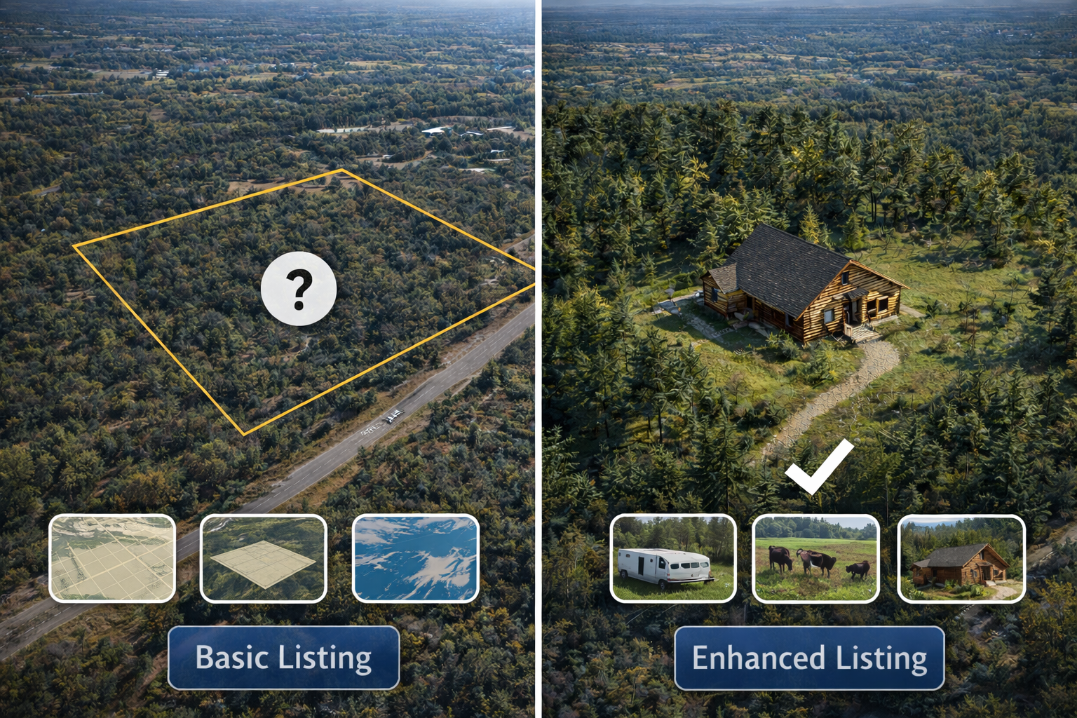
Photos have a fundamental problem: they can’t answer the questions buyers actually have.
When buyers look at flat images of raw land, they struggle to understand:
- How big does 10 acres actually feel?
- Where exactly are the boundaries — relative to the road, the trees, the creek?
- What’s the terrain like — is there a buildable flat spot, or is it all slope?
- What would it look like to actually be standing there?
A 3D property viewer like ParcelView3D pulls real elevation data and satellite imagery to build an interactive terrain model of your parcel — embedded directly on your listing page. Buyers can rotate, tilt, zoom, and fly through the land before ever contacting you.
- Terrain and slope become immediately obvious
- Road access is visible from the 3D overlay
- Boundaries are shown in context — not just on a flat plat map
- Buyers build a sense of place before they ever reach out
- Qualified inquiries go up — buyers who contact you already understand the property
- Tire kickers go down — 3D answers their questions before they waste your time
AI Concept Images: Answering “What Could This Become?”
Terrain answers the what is it question. But buyers also need help answering what could this be?
Land buyers are aspirational purchasers. They’re not buying 5 acres of raw land in East Texas. They’re buying the version of their life where they have a weekend retreat, a place to retire, or somewhere to park the fifth wheel and disappear for a month.
AI concept images — built into ParcelView3D — let you generate realistic visualizations of what a property could look like with a cabin in the clearing, an RV setup near the treeline, or a small homestead with a garden.
Listings with AI concept imagery consistently generate more inquiries, longer time-on-page, and more emotionally invested buyers — because you’ve done the imaginative work for them.
Before and After: The Same Parcel, Two Very Different Results
Consider a 12-acre parcel in Middle Tennessee. Rolling terrain, mature hardwoods on the back half, gravel road frontage, seasonal creek along the east boundary.
| ✗ STANDARD LISTING
6 drone photos Flat county parcel map “12 acres, road frontage, creek, hardwoods.” Price and phone number only |
✓ PARCELVIEW3D LISTING
Interactive 3D terrain viewer embedded on listing page AI concept image of a cabin clearing near the creek Feature badges: camping, no HOA, creek frontage, road access Same price and contact info |
The information is identical. The experience is completely different. The second listing answers questions before they’re asked, builds emotional investment before contact is made, and signals to buyers that you’re a professional who takes their investment seriously.
When Quality Presentation Matters Most
By Property Value
- Under $25K: Basic quality photos may suffice
- $25K–$75K: 3D visualization shows clear ROI
- $75K+: Quality presentation is essentially mandatory
- $150K+: Every visual advantage you can get pays dividends
By Property Type
- Remote/rural land: 3D visualization is critical — buyers can’t easily visit
- Recreational properties: Need to show terrain, views, and outdoor features
- Development land: Buyers need to visualize the potential
- Unique or high-feature properties: Stand out from commodity listings
By Market Conditions
- Competitive markets: Professional presentation is table stakes
- Slow markets: Quality visuals capture limited buyer attention
- Remote buyer markets: Virtual tours are effectively required to transact
The Bottom Line
Land selling isn’t about spending more on marketing — it’s about not leaving money on the table through weak presentation.
The data is clear:
- Quality visuals command 8–15% higher sale prices
- Professional presentation sells properties 40–60% faster
- 3D tours expand your buyer pool by 3–5x
- Remote buyers — your largest untapped market — require virtual tours to buy with confidence
For most properties over $25,000, the ROI on professional-quality 3D visualization isn’t a question. The only question is how you get there.
See what your listings look like in 3D
Enter any parcel address and watch it come to life in under a minute.