PARCELVIEW3D · SOLUTIONS GUIDE
You built the site. The listings are live. So why do buyers still call and ask what the land actually looks like?
It is a fair question, and it comes up on nearly every demo call. You already paid for a website. It has your logo on it, your inventory, your phone number, and an inquiry form that works. Adding another tool can feel like paying twice for the same job.
Here is the distinction that usually settles it: your website is where a buyer finds the property. ParcelView3D is where they understand it. Those are two different jobs, and most land and home websites — including genuinely good ones — are only built to do the first.
The short answer
A website publishes information. ParcelView3D lets a buyer explore the property.
ParcelView3D is not a replacement for the site you already have. It is an interactive 3D property viewer that drops into the page you already built — same domain, same theme, same lead form. The buyer never leaves your site. They just get to do something on it that a photo gallery cannot let them do: pick up the parcel, turn it around, and answer their own questions before they ever contact you.
Your website proves the property exists. It cannot prove what it is like.
Think about the last five inquiry emails you answered. Odds are they sounded like this:
- “Is any of it in the floodplain?”
- “How steep is the back half?”
- “Where exactly does the road touch the property?”
- “Is that tree line the boundary, or is that the neighbor?”
- “Can you send more pictures?”
Every one of those is the same problem wearing a different hat. A photograph is a single frozen viewpoint that you chose. The buyer wants a viewpoint that you did not choose — and until they get it, they either email you or they quietly move on. Most of them move on. That is what “the listing got traffic but no calls” actually looks like from the buyer’s side of the screen.
It gets sharper with out-of-state and out-of-market buyers, who make up a large share of land and lot purchases. They are not driving out on Saturday to walk it. The only site visit they are going to get is the one you give them online.
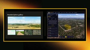
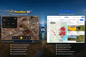
Figure 1 — The same property presented two ways: static photos on the left, interactive exploration on the right.
What ParcelView3D actually changes on your site
This is the part that surprises people: you do not migrate anything. Your website stays exactly where it is. You paste one embed block into a listing page — in WordPress, Squarespace, Wix, Shopify, GoHighLevel, Carrot, or plain HTML — and that section of the page becomes an interactive 3D view of the property, with your branding on it.
Everything that made your site worth building stays yours:
- Your domain and the SEO you have earned on it
- Your theme, colors, and logo
- Your lead form and your CRM — captured leads route where you already send them
- Your existing photos, descriptions, and terms
- Full control — the embed comes out as easily as it went in
Five things a website cannot do on its own
1. Let the buyer walk the land without leaving the couch
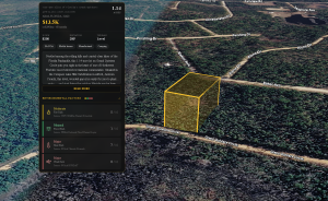
Rotate, tilt, zoom, and fly the parcel with real elevation and the property lines drawn on it. Slope, tree cover, road frontage, and how the parcel sits against its neighbors stop being adjectives in your listing copy and become something the buyer sees for themselves.
2. Answer diligence questions on screen instead of in your inbox
Toggle overlays for flood, wetlands, zoning, topography, mineral rights, and climate risk right on the property. Sellers consistently report the same result: the volume of email drops, and the calls that do come in are from people who already checked and still want it.
3. Show what could be built there
Raw land is a hard thing to fall in love with, because most buyers cannot picture the finished version. ParcelView3D generates concept renderings placed on the property, cinematic flyover videos, and an AI build cost estimator that puts a real number on a home, cabin, ADU, or manufactured build — including site prep items like well, septic, driveway, and clearing. The buyer stops asking “what is it worth?” and starts asking “what would mine cost?”
4. Follow the buyer off your website
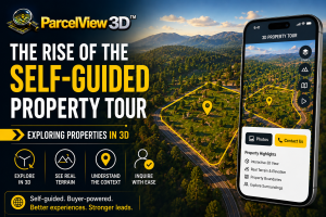
Every property also gets a mobile-first PropCard™ — one shareable link with the 3D viewer, photos, pricing, and lead capture on it — plus a print-ready QR code. That means the yard sign, the flyer, the Facebook post, the email blast, and the text you send at 9 p.m. all point to the same interactive experience. A drive-by scan turns into a full property tour before they reach the end of the road.
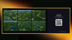
Figure 2 — One property, multiple ways to access it. Scan the QR code to open the same interactive property experience on your phone.
5. Tell you which buyer is actually serious
A standard website analytics report tells you a page got visits. ParcelView3D tells you how long buyers spent exploring, which properties held attention, and which specific lead came back to tour the parcel a second and third time. That is your follow-up list, sorted for you.
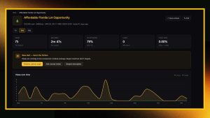
Figure 3 — Engagement and lead data for each property, helping you identify buyer interest and prioritize follow-ups.
“Could I just get drone photos or a video package instead?”
You could, and good aerial media is worth having — a well-shot flyover still sells. But it is a finished film: it shows the property from the angles the operator chose, on the day they were there, for the price of a shoot on every single listing. When your terms change or the parcel gets split, you shoot it again.
ParcelView3D hands the camera to the buyer instead. Every listing in your portfolio gets the same interactive treatment from your desk, in minutes, with no site visit, at a flat monthly cost that does not climb with your inventory. Update a price or a boundary once and it updates everywhere the listing is embedded.
Plenty of sellers run both, and that combination works well: use produced video to stop the scroll in an ad, and send that traffic to a ParcelView3D listing where the buyer can dig in as long as they want.
How the options compare
| Your website alone | Drone photo / video package | ParcelView3D | |
| Buyer controls the view | No | No — fixed footage | Yes — rotate, tilt, zoom, fly |
| Time to publish a listing | Hours of page building | 1–2 weeks per property | Minutes, from a parcel number |
| Cost per property | Your time | Hundreds per property | Included in a flat monthly plan |
| Site visit required | Yes, for photos | Yes | No — done from your desk |
| Answers diligence questions | In text, if you wrote it | Only what the camera saw | On screen, with overlays |
| Works across a whole portfolio | One page at a time | Cost scales per property | Yes — bulk import your inventory |
| Tells you who engaged | Page views only | Not applicable | Views, time explored, repeat buyers |
| Stays current if terms change | Manual edit | Reshoot | Edit once, updates everywhere it is embedded |
Comparison reflects typical seller experience; results vary by market, listing quality, and follow-up.
What it takes to add it
Less than most people expect, and it does not require you to become a software person.
- Enter the parcel number — or bulk-import your whole portfolio from a CSV. Boundaries and property details populate automatically.
- The 3D listing builds in seconds. Add your photos, pricing, and terms if you want them.
- Copy the embed block onto your existing listing page, or just share the PropCard link and QR code.
Plans start at $9/mo and scale with the size of your portfolio, and there is a 7-day free trial with no card required so you can put a real listing in front of real buyers before deciding. See current plans and pricing for the full breakdown.
See it before you decide
The fastest way to answer this question is to stop reading about it and go use one. Open a live ParcelView3D listing and do what your buyer would do — drag to rotate, scroll to zoom, tilt down to the road, and toggle the overlays.
▶ Try the live 3D listing: parcelview3d.com/embed/49e8c66a46a81ebe286fd928b4e759f7
▶ Book a 15-minute walkthrough: parcelview3d.com/demo
▶ Start free — 3 properties, no card: parcelview3d.com
The bottom line
You do not need ParcelView3D because your website is bad. You need it because a website — any website — can only publish. It can show a buyer that a property exists, list its acreage, and take their email address. It cannot let them stand on the high corner of the parcel and look down the road frontage at ten o’clock at night from four states away.
That gap is where deals stall: the buyer who was interested but not confident, who did not want to be the person asking five questions, so they closed the tab. Interactive 3D closes the gap. Your website keeps doing the job it was built for — and the listing page starts doing something it never could before.
ParcelView3D™ — 3D property visualization for land sellers, builders, and developers. parcelview3d.com