Why the next decade of land and real estate transactions will be won (or lost) on visual clarity
Walk into any real estate brokerage in 2026 and you will hear the same complaint from agents, investors, and buyers alike: the gap between what a property looks like online and what it actually looks like in person is still embarrassingly wide. We have AI-generated listing descriptions, drone photography, and matterport tours of every kitchen and bathroom in America — yet when a buyer wants to understand the land itself (the topography, the access road, the neighbors, the surrounding parcels, the floodplain creeping in from the east) they are usually still squinting at a flat satellite screenshot from a decade ago.
That gap is closing faster than most agents realize. Immersive 3D property visualization has crossed the threshold from novelty to necessity, and the brokerages, land investors, and developers who recognize this shift are quietly rewriting how due diligence happens. The ones who do not are about to find themselves losing deals to competitors who can let a buyer in Phoenix walk a 40-acre parcel in rural Tennessee from their couch — and feel confident enough to send a deposit before ever boarding a plane.
The Static Listing Era Is Officially Over
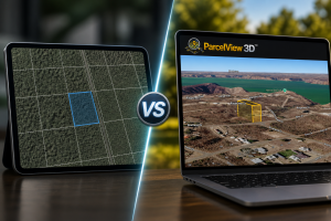
For twenty years, the standard real estate listing has been a remarkably stable document: photos, a paragraph of description, a static aerial image with a red boundary line, and maybe a PDF survey if the agent was thorough. This format worked when most buyers eventually drove the property before writing an offer. But the buyer pool has changed.
Out-of-state and remote buyers now account for a meaningful share of transactions in every major land and rural real estate market in the United States. Owner-financed land buyers, in particular, often purchase parcels they will never physically visit before closing. Investors are bidding on portfolios of dozens of properties scattered across multiple states. Wholesalers are flipping contracts in markets where they have never set foot. In each of these scenarios, a static aerial image is not just outdated — it is a liability. It hides exactly the things a remote buyer needs to see: how steep is the slope down to the creek, is there a gully cutting through the buildable area, is the neighbor running a junkyard, is the access road actually passable in a sedan.
Immersive 3D visualization solves all of these problems in a single browser tab. And once a buyer has experienced it, the static aerial feels like watching a black-and-white television in 2026.
What Buyers Actually Want From a Visualization Tool
After thousands of customer interactions across the land investment space, a clear pattern has emerged in what remote buyers actually want from a property visualization experience. It is rarely cinematic flyovers or VR headsets. It is almost always the boring, practical fundamentals — done well:
- The ability to rotate the view and see how the land actually slopes.
- A clear, accurate parcel boundary that does not float six feet above the ground or drift twenty feet east of where the survey says it should be.
- The neighbors. Not just the parcel, but what is next to it, behind it, and across the road.
- A sense of access — where the road meets the property, how far the driveway needs to run, whether there is a culvert or a fence to deal with.
- The surrounding context: nearest town, nearest highway, distance to the lake, distance to the regional airport.
- Confidence that what they are seeing is current, not a 2018 snapshot from before the new subdivision went in down the road.
The brokerages and land investors who deliver these six things consistently are closing deals at meaningfully higher rates than those who do not. The ones who try to deliver them with screenshots and a paragraph of description are losing those same deals to anyone who can show, not tell.
Why Generic Tools Keep Falling Short
The real estate industry has a long history of adopting generic technology and bending it awkwardly to fit property workflows. CRMs designed for B2B sales teams. Email platforms designed for newsletters. Project management tools designed for software developers. Every one of these tools eventually got displaced by purpose-built real estate software because the generic versions could never quite handle the specific data and specific workflows the industry requires.
Visualization is following the exact same pattern. Generic visualization platforms — the kind designed for game developers, architectural firms, or general-purpose 3D modeling — can produce gorgeous output, but they were never built around the things real estate actually needs: parcel boundaries, ownership data, school districts, zoning overlays, flood zones, comp pins, and a workflow that lets an agent generate a shareable link in under sixty seconds without opening a desktop application.
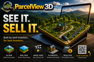
This is the gap purpose-built platforms are now filling. ParcelView3D, for example, was designed specifically for land professionals from day one rather than retrofitted from a generic visualization stack. The result is that a land investor can paste a parcel ID, generate a shareable, embeddable 3D experience for that specific property, and send it to a buyer inside an existing CRM workflow — all within the same minute. Tools like CloudRF or generic GIS viewers can technically render terrain, but they expect the user to bring their own boundary data, their own ownership records, their own context layers, and their own comfort with technical interfaces. For an active land investor managing dozens of listings, that overhead is the difference between adopting the technology and abandoning it.
The Trust Equation: Why Visualization Closes Remote Deals
There is a deeper reason visualization is reshaping real estate, and it has nothing to do with the technology itself. It has to do with trust.
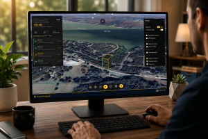
A remote buyer who has never met the seller, has never visited the property, and is being asked to wire money sight-unseen is operating in an environment of high uncertainty. Every uncertainty is a friction point that delays the deal or kills it. Static photos reduce some uncertainty but introduce new ones — what is the photographer not showing me? Drone videos reduce more uncertainty but raise others — was this filmed last week or last year? An interactive 3D experience that lets the buyer pan, rotate, zoom, and explore the surrounding parcels themselves does something different: it transfers control. The buyer is no longer being shown a curated view. They are exploring.
That shift, from being shown to exploring, is the single largest psychological lever in remote real estate transactions. It is why brokerages that adopt immersive visualization see measurable lifts in time-on-listing, in inquiry-to-offer conversion, and in offer-to-close conversion for out-of-state buyers. It is also why owner-financed land sellers who add a 3D experience to their property pages report fewer down-payment refund requests and fewer post-closing complaints — buyers who explored the property on their own time before paying a deposit have already worked through the questions that would otherwise become problems six weeks later.
Three Predictions for the Next 24 Months
If you are an agent, broker, land investor, or developer trying to figure out where to put your time and dollars, here are three trends that are very likely to define the next two years in this corner of the industry:
First, MLS integration of immersive visualization will become a competitive battleground. The brokerages and MLSs that figure out how to standardize a 3D property experience field — the way they once standardized photo galleries and virtual tours — will pull listing inventory toward themselves. The ones that treat 3D as a niche add-on will watch their listing counts erode.
Second, owner-financed land and rural real estate will lead adoption, not luxury. Counterintuitive, but predictable: the markets where buyers are most likely to be remote, most likely to be uncertain, and least likely to have walked the property in person are the markets where visualization delivers the most value. Land investors are already three or four years ahead of urban residential brokerages on this curve, and the gap is widening.
Third, the platforms that win will be the ones that bundle visualization with the rest of the deal stack — listings, lead capture, CRM, comps, mailing, and follow-up — rather than asking agents to stitch together five different tools. Standalone visualization is a feature. Integrated visualization is a workflow. Workflows win.
What This Means for You
If you are reading this as a working agent, broker, or land investor, the practical takeaway is simple. The buyers in your pipeline today are already comparing the experience you give them with experiences they have had elsewhere — even outside real estate. They have spent the last decade exploring restaurants, hotels, vacation rentals, and even cars in immersive environments. When they land on your listing and find a flat satellite snapshot from 2019, they are not impressed by your restraint. They are wondering what else you are not showing them.
The good news is that catching up is cheap and fast. A purpose-built platform like ParcelView3D can take a brokerage from zero to a complete visualization workflow in a single afternoon, with shareable links, embeddable viewers for existing websites, and integrations into the tools your team already uses. There is no excuse left for static-only listings, and the agents who realize this in 2026 are going to spend the next few years quietly taking market share from the ones who do not.
The static listing era is over. The question is not whether your market will move to immersive visualization — it is whether you will be the one moving it, or the one moved aside by it.
ParcelView3D pricing and plans — Free, Starter, Growth, and Pro tiers for teams of every size.