A side-by-side look at features, pricing, and real-world fit — so you can pick the platform that matches how you actually work.
| QUICK VERDICT | ParcelView3D: best for selling & marketing land | AcreValue: best for farmland valuation research |
The Big Picture
If you sell land — whether raw acreage in Texas, rural homestead lots in Tennessee, or owner-financed tracts in Florida — the question isn’t which mapping tool looks nicer in a screenshot. It’s which one helps you close more deals. To answer that, it helps to understand what each platform was actually built to do.
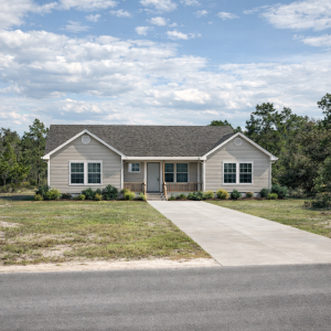
ParcelView3D is a listing-first platform purpose-built for land sellers, builders, and developers. It takes a property from coordinates to a polished, shareable 3D showcase in under a minute. Every feature — cinematic flyovers, AI-generated concept images, cinematic 10-second video clips, AI build cost estimates, branded PropCards — exists to help a buyer visualize, emotionally connect with, and ultimately purchase a piece of land they may never have set foot on.
AcreValue is a farmland-valuation platform with deep agricultural roots. It analyzes soil composition, climate data, crop rotations, taxes, interest rates, and commodity prices to produce estimated values for individual fields. It is well-suited for farmers, ag lenders, and appraisers who need data-driven valuations of working farmland.
Both tools serve land professionals — but they solve different problems. This comparison breaks down the platforms across four dimensions that matter most: 3D visualization and presentation, AI-powered marketing tools, listing experience, and pricing.
3D Visualization & Presentation
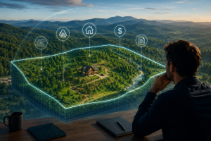
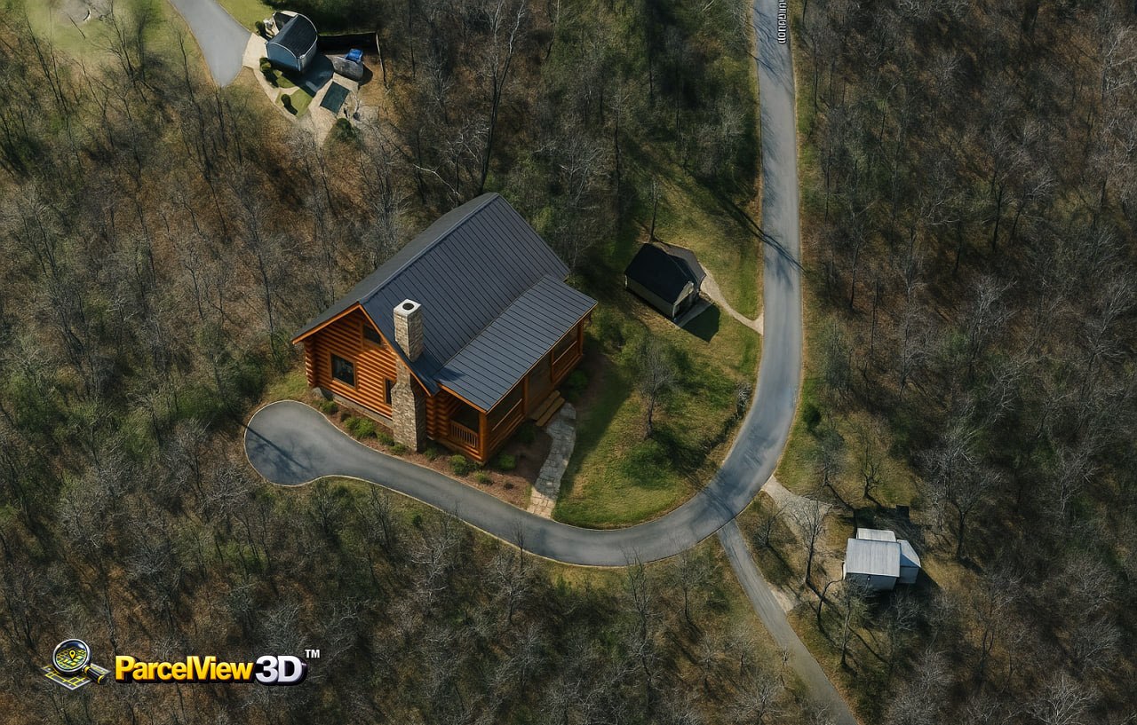
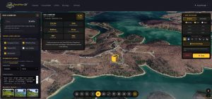
This is where the two platforms feel most different. ParcelView3D delivers a fully immersive, photorealistic 3D experience. Valleys, ridgelines, creek bottoms, and hilltops render in genuine three-dimensional space, and the automated flyover orbits each property at a cinematic camera angle. Three flyover speed settings let you tailor the motion to a quick scroll-stopping clip on social media or a slow, deliberate walkthrough during a client meeting.
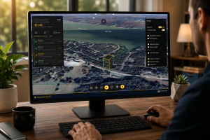
Presentation Mode takes that even further. Connect a laptop to a TV, projector, or big screen at your office or trade-show booth and ParcelView3D auto-detects the wide screen, switches to a widescreen layout with abbreviated pricing, opens a fullscreen lightbox gallery, and prints a QR code on the corner so your client can pull the listing up on their phone before they leave the room. It is a sales presentation engine, not just a map.
AcreValue is built around a 2D mapping interface optimized for layered agricultural data — soil ratings, crop history, land cover, and parcel boundaries. It is excellent for visualizing data, and that is genuinely useful for the audiences AcreValue serves. For a land seller trying to make a buyer feel a piece of land, however, a flat data map is a different category of tool. ParcelView3D is designed exactly for that emotional “picture yourself here” moment, and it is built around that single job.
| Why this matters for land sellers
Land buyers don’t buy dirt — they buy a future. A buyer scrolling Facebook will stop on a cinematic flyover. They will not stop on a soil productivity map. Both have value; only one moves a listing to the top of someone’s weekend conversation. |
AI-Powered Marketing Tools
ParcelView3D ships with three AI tools that AcreValue doesn’t offer:
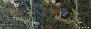
- AI Concept Builder — Upload a property image and generate HD renderings showing what a ranch home, modern cabin, ADU, or barndominium could look like on that exact land. Driveways, landscaping, and realistic lighting included.
- AI Cinematic Video — Auto-generate 10-second flyover clips with motion, lighting changes, and atmosphere. Pro-tier subscriptions include voice narration overlay so you can talk over the video.
- AI Build Cost Estimator — Show buyers exactly what it would cost to build on the property. Single-family home, mobile, manufactured, cabin — plus a site-prep breakdown covering well drilling, septic, electrical, driveway, clearing, and foundation. Includes a well feasibility score from USGS groundwater data and septic suitability from USDA soil analysis. The total estimated investment combines land + build + site prep into one number a buyer can act on.
These three tools answer the buyer’s biggest unspoken question: “Can I picture myself there, and can I afford to build there?” For owner-financed land sellers whose buyers are often making purchase decisions from a couch in another state, this is decisive. AcreValue’s strengths lie elsewhere — its valuation algorithm, soil data, and crop history are genuinely useful for ag-focused work — but it doesn’t generate marketing content. So if your goal is to market raw land to retail buyers, ParcelView3D is the more direct fit.
| The closer move
An AI-generated cabin on the actual parcel + a cost estimate showing land + build + well + septic = a buyer who has already mentally moved in. That is the conversation that closes deals. |
Listing Experience & Buyer Engagement
Every property in ParcelView3D becomes a PropCard — a beautiful, mobile-first landing page with a live 3D viewer, photo gallery, AI concepts, video, pricing, and a built-in lead-capture form. PropCards include QR codes designed for print: yard signs, flyers, business cards, postcards, and trade-show banners. Anyone who scans is dropped straight into your branded listing page with the 3D viewer already loaded.
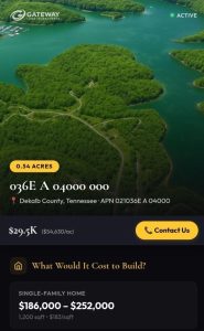
Every property gets a mobile-first PropCard with 3D viewer, QR code, lead capture, and verified badges.
Labels and badges adapt automatically to your business type — Verified Seller for land investors, Verified Builder for home and ADU contractors, Verified Contractor for remodelers, Verified Developer for development firms. Pricing terminology adapts too: “Cash Price” for land investors, “Build Cost” for ADU builders, “Project Value” for developers. One platform, five business types, zero awkward terminology.
AcreValue is not designed as a buyer-facing listing platform. It does have a listings section that aggregates land for sale across the country, but the per-property page is data-centric rather than presentation-centric. There is no immersive 3D viewer, no AI concept image of what could be built, no cinematic flyover, and no branded landing page that lives on your own domain. That is by design — AcreValue’s mission is research and valuation, not marketing — but it does mean the two platforms aren’t really competing for the same job.
Feature-by-Feature Comparison
✓ = Included ✗ = Not available Partial = Limited or use-case dependent
| Feature | ParcelView3D | AcreValue |
| 3D VISUALIZATION & PRESENTATION | ||
| Photorealistic 3D terrain view | ✓ | ✗ |
| Automated cinematic flyover | ✓ | ✗ |
| Adjustable flyover speed | ✓ | ✗ |
| Presentation Mode for big screens | ✓ | ✗ |
| Boundary overlay in 3D space | ✓ | ✗ |
| AI-POWERED CONTENT | ||
| AI concept image generator | ✓ | ✗ |
| AI cinematic video creator | ✓ | ✗ |
| AI build cost estimator | ✓ | ✗ |
| Site prep cost breakdown | ✓ | ✗ |
| Well & septic feasibility analysis | ✓ | ✗ |
| LISTING & MARKETING TOOLS | ||
| Branded listing pages (PropCards) | ✓ | ✗ |
| QR codes for print marketing | ✓ | ✗ |
| Embeddable property viewer | ✓ | ✗ |
| Lead capture form | ✓ | ✗ |
| View analytics per listing | ✓ | ✗ |
| Custom branding (logo, colors) | ✓ | ✗ |
| Industry-tailored labels | ✓ | ✗ |
| PROPERTY DATA & RESEARCH | ||
| Parcel data — all 50 states | ✓ | ✓ |
| Soil productivity ratings | Partial | ✓ |
| Crop history (5+ years) | ✗ | ✓ |
| Farmland valuation algorithm | ✗ | ✓ |
| Comparable sales database | Partial | ✓ |
| Mortgage data lookup | ✗ | ✓ |
| Critical energy infrastructure | ✗ | ✓ |
| USE-CASE FIT | ||
| Land marketing & sales | ✓ | Partial |
| Owner-financed land | ✓ | ✗ |
| ADU and home builders | ✓ | ✗ |
| Active farmland appraisal | Partial | ✓ |
| Buyer-facing presentations | ✓ | ✗ |
| Crop-rotation planning | ✗ | ✓ |
Pricing: Simple vs Custom
ParcelView3D uses a straightforward tiered model starting at $9 per month, scaled by the number of properties and monthly views. Free trial included on every plan, and AI features are unlocked starting at the Growth tier ($99/month). Tokens for AI concept images and AI videos can also be bought in standalone packs that never expire — so you can scale usage up for a launch month and back down without changing your subscription.
AcreValue uses a tiered subscription model with a free entry tier and paid plans for professional and enterprise use. Detailed land reports are sold per-report in select states. Pricing for higher tiers is typically shared on request rather than published openly. For a land seller who just wants to see what a tool costs before they sign up, ParcelView3D’s published pricing page makes that easier.
| ParcelView3D | AcreValue |
| Free trial available | Free tier with limited features |
| Basic — $9 / month (3 properties) | Professional plans — pricing on request |
| Standard — $19 / month (10 properties) | Enterprise plans — pricing on request |
| Starter — $49 / month (25 properties) | Land reports — per-report fees in select states |
| Growth — $99 / month (50 properties + AI estimator) | |
| Pro — $199 / month (100 properties + API + unlimited AI) |
Who Should Use Which Tool?
Choose ParcelView3D if you are:
- An owner-financed land seller who needs buyers to emotionally connect with property they may never visit in person
- A land investor who treats marketing assets — AI concept images, cinematic videos, immersive 3D flyovers — as your competitive edge
- An ADU contractor or home builder who walks clients through site feasibility, build costs, and 3D concepts before bidding
- A real estate professional who presents to clients on big screens and needs a polished, branded presentation tool
- A website owner who wants embeddable 3D listings on your own domain instead of someone else’s marketplace
- Selling 5 to 100+ properties at a time and want a clean dashboard for views, leads, and content generation
Choose AcreValue if you are:
- A farmer or ag lender researching the productive value of working cropland
- An ag appraiser building comp reports for farmland transactions in major ag states
- A landowner wanting an algorithmic estimate of your field’s value based on soil, climate, and commodity prices
- Tracking crop-rotation history, mortgage data, or critical energy infrastructure for agricultural decisions
- Building an agricultural network and connecting with other landowners and farmers
| The pairing nobody talks about
Many serious land investors use both. AcreValue for back-end research on farmland comps and soil data; ParcelView3D for the front-end marketing that actually turns leads into buyers. They serve different stages of the same pipeline. For under $200/month combined at most realistic usage levels, the pairing gives you a meaningful edge over competitors using neither. |
The Bottom Line
If you’re choosing one tool to close more land deals, market more effectively, and present properties like a pro, ParcelView3D is built for exactly that. It turns every property in your inventory into a cinematic 3D experience, gives buyers an AI-generated vision of what could be built and what it would cost, and packages everything into a branded, mobile-first PropCard with QR codes for print and lead capture for follow-up.
If you’re choosing one tool for farmland valuation and agricultural research, AcreValue is a capable platform with strong soil and crop data. The two tools aren’t really substitutes — they are complements that solve very different problems.
| BEST FOR SELLING & MARKETING LAND
ParcelView3D Immersive 3D viewing, AI concept images, cinematic videos, build cost estimators, branded PropCards, QR codes, and view analytics. |
BEST FOR FARMLAND VALUATION
AcreValue Soil productivity, crop-rotation history, farmland valuation algorithms, comp sales, and agricultural data layers. |
Ready to present your properties like a pro?
Try ParcelView3D free — no credit card required.
Start your free trial: https://parcelview3d.com/register/
Learn more: https://parcelview3d.com/